Just a quick post - no photos unless I come across any later. Last weekend we drove down to the Catskills to run along the Escarpment Trail in the annual 30K race. I had done it once before, 2 years ago when I decided that it was a fun race and that John would likely really enjoy it. We were both skeptical when it was pouring rain during the bus ride to the start, but it turned out we both really enjoyed the day.
John nabbed a prime spot under the U-Haul van to stay mostly dry during the pre-race briefing, then we were off with the crowds funneling onto the singletrack trail. John started near the front and I was content to find my place mid-pack for the long climb up to Windham High Peak. The rain mostly stopped and it turned into simply a lovely day for running - cool and wet, occasional drops of water from either rain or wind blowing rain down from leaves.
The main challenge was the slickness of some of the rocks. The dirt actually held up pretty well, more tacky than slippery for the most part, and the occasional mud puddle was nothing compared to what I've seen so far this summer. I determined I would focus on the climbs and take it easy on the downhills. Normally I pass a lot of people on the technical downhills but today I was content to follow and pick my way down.
John had a blast on the descents, I was happy to hear later.
It was the greenest tunnel of a trail I have ever seen in that area. For having been there multiple times in various seasons, I still lost track of where I was. Just green trees and vegetation, rocks and roots at my feet, a few shorts climbs and descents, and absolutely no view through the fog. We really have had a lot of rain this summer.
I was happy because running felt good. The woods smelled good (I don't often have a sense of smell). Some really pretty birds were singing away. Sometimes the wind would blow a little. I wasn't stuck behind long trains of runners when there was runnable trail, so I could just lope along and enjoy the day.
I saved some climbing energy for the big haul up to Black Head Peak. Yep, still a doozy! It was steep but my legs and lungs handled it well. Not far from the top there was a guy ringing a cowbell and cheering people on. Slightly distracted, I moved over to the right side of the trail and stepped up to bang the top of my head into an overhanging rock. Dang it, I'm supposed to be more careful than that. Oh well, I guess I have a hard head because it hurt only for a moment.
Yay, there's the top! The drop off the nose of the peak has several steep rocky sections. I'm slowly learning the best way down each of them, mostly with help from my hands. I expected a whole herd of runners to come flying past me here but only a couple did. The switchbacks down to Dutcher Notch were fun and I started singing "Mambo Number 5" in my head to get my feet dancing.
Oh yeah, I can dance down these things! It has been too long since I remembered how to do that. Short steps, quick strides, pick up my feet. 1, 2, 3, 4, 5, everybody in the car so come on let's ride... joyful stepping through rock gardens and having a blast.
One last big climb to focus on - the 3-step process for getting up to Stoppel Point. My quick cadence was helping on the uphill too, and I started passing other runners a bit here and there. The flat sections in between each ascent were fun and I loved having legs that wanted to keep going. Then there was the airplane wreckage, almost to the top. Just about there my muscles started getting a bit tired, nice timing.
The aid station on top was rocking with streamers and music and happy volunteers. Funny!
I knew it was a lot of rocks and work to get to North Point, but at least the last several miles were generally downhill. They also take longer than you might think, but I was having such a great time that I didn't mind. Then there was the open field and rocks slabs, making progress.
I stepped on one rounded rock that was more slippery than expected and ended up sliding off that step-down. I put my hands down to stop myself, and mostly landed on my new Camelbak bottle. It absorbed the brunt of the fall and as I was appreciating that I was also listening to a jet of water "SQUIRT" out in front of me. I paused to make sure nothing was hurting, just a tiny scrape on the other hand. All the little post-race pokies are above my waist, that's new.
I didn't intend to stop at the final aid station at North Point but I told them my story about falling on my water bottle and how I could use more water as a result. Oh yes, I'm fine, just a little short on water! Normally there would be a great view from here but all we got on Sunday was more fog.
A couple more miles, familiar trail and rocks, more fun down-climbs, "Bad Man's Cave", a couple more viewpoints without views. Still able to run the occasional flat stretch but the really technical stuff slowed me down. However, only a couple guys caught and passed me through here so I guess I wasn't doing too badly. I was just happy my legs weren't cramping like in 2011 - that had made some of these clambers way more difficult than they needed to be. Much better this time.
And I still broke the 5-hour mark, so yay for that! I came through the finish line all smiles declaring, "that was FUN!" and John grinned at me and agreed.
Tuesday, July 30, 2013
Thursday, July 25, 2013
Vermont 100
The Vermont 100 was less of a party this year without so many of our friends joining us for the adventure. We still had a great time with Kip and we were happy to visit with Mom on Sunday/Monday.
This is about as "party" as we could make it :)

Hanging out at the pre-race briefing / supper:

Several of the runners who are working toward a Grand Slam, having finished Western States. After this comes Leadville and Wasatch. Good luck you crazy guys!

It was nice to spend some time with Steve from Albany before (and after) the race. Ready to get this show on the dirt road:

We were treated to a fireworks display at 3:55 a.m.! How cool is that. An hour later there were some loud "booms" reverberating through the woods and we eventually determined that they must have repeated it for the start of the horse race. I'm not sure I would have appreciated it quite as much if I were sitting atop a horse.

At least John is in focus for this shot, just before the start:

Kip was much further toward the front of the field - apparently he led the race for a few feet at the start, go Kip go!

We headed off down the dirt road for a ways, up another road, and then started up a narrow trail. I used a micro-light and mooched off the bright lights around me. That worked up to a point, until I wanted to climb a bit faster and had to jump ahead to another group with good lights. So maybe I could have carried something just a little brighter...
My original goal for this race was to try for even pacing throughout the day and night. I also wanted to focus on climbing well, taking it easy on the downhills, and doing some "zen" on the occasional flat sections. Then I got caught up in how good I felt on the uphills and actually pushed the pace a bit more than perhaps was prudent.
A bit more trail and then we were on roads, mostly uphill, past a couple unmanned aid stations, and eventually into Woodstock. I tried to be careful on the long paved downhill into town. My legs felt a lot better than at this point last year, so I thought that was encouraging. I was making up about 2-3 minutes per aid station section compared to last year as well. Thoughts of a PR (personal record) drifted into my head.
Kip is all smiles as he greets John in Woodstock:

I actually look like I'm running! That might be a sign that I'm moving too fast... Hi John!

I still felt pretty good through the Taftsville Bridge aid station and along a flat-ish road to the next set of climbs back into the hills. My climbing legs were happy so I was happy.
The fields and farms were beautiful in this section - this is where I always have the mental energy to notice things like that. Also this sign which made me laugh:

A short section of double-track trail felt really nice. Then some more road and on to the first crewed aid station where we would see John. Yay John!
Kip running in to Pretty House aid station:

Marcy running in to Pretty House:

Kip arrived over 20 minutes before I did, nice work. I was doing well vs. my 2012 splits and I tried to get through the aid station quickly. There was a bit of wind and sprinkling rain, ah that felt great. I asked John if he could get us some more of that, and he said he would work on it.
John noticed this license plate and got a photo for me - thanks John! Funny thing was the same guy appeared near me later on the course to take pictures of the gorgeous field around mile 46 and I also noticed the plate. I can hear George Takei in my head...

The first couple miles out of Pretty House I remembered well from last year, including a couple rather steep uphills. Then I lost track of where we were, and the U-Turn aid station seemed like it was in a completely different place. Here's the first split where I lost time compared to 2012, and although I was thinking that the course might have been rerouted, I didn't remember how the mileages compared and it seemed like I was losing ground.
More trail that didn't look familiar. Finally we crossed a small road and things started looking like I remembered. Ah yes, here's the big wide open field on top that people call "Sound of Music Hill" - very pretty! We had great views again.
Big downhill, several steep downhill spots where my knees asked me to take it easy. No problem, try to stay smooth. The road down to the next aid station seemed shorter than I remembered, that's always nice. My total time, however, didn't seem to reflect the extra work I had been doing compared to last year. That was slightly disappointing.
Kip running down the hill to Stage Road - looking good!

The steep climb up the next meadow was memorable in several ways. Here is where I first remember running into stinging nettle around my ankles, ow. This was while trying to avoid the big mud puddles that had a ton of horse and runner footprints through them. I was partially successful in at least keeping my heels dry (they were well taped after last weekend's issues but I didn't want to stress it). Also, I saw a few raspberries and managed to find a good one - Berry Quest complete!
Finally into the woods, a few more mud puddles that were easier to avoid, some nicer trail, a road down to route 12 and a manned aid station. I believe I started eating pieces of fruit here, starting with some yummy cantaloupe. Later on the course I found watermelon (awesome!) and even a couple cherries. Back up into the woods.
I mixed and drank a half serving of Spiz at the Vondell Reservoir. Also finally found an alternative to the few-and-far-between porta-potties with a spot in a field, much better...
A bunch of folks were out cheering for a runner ahead of me on the road to the covered bridge, that was fun to watch. I was still running quite a bit of the downhills, flats, even the gentle uphills. It was great being better trained this year, although I might have taken that for granted and pushed too much when I felt good early on.
Finally the uphill started to get just a bit difficult on the long steep climb to Barr House. That climb takes a while to get started but then doesn't seem to ever end. Did I mention that it's steep? Steep is not usually my forte. Finally... phew.
I felt fine on the long downhill to the paved road, gradually passing people while still trying to take it easy. A whole herd of guys followed me out of the next aid station and proceeded to leave me in the dust on the paved climb along the busy road. I don't blame them, I was happy to get that "zooming cars" part over with too.
A couple horses passed me on the next narrow trail, and I saw a few more horses coming up from behind. I decided it would be nice to get to the dirt road before they caught up, so I worked hard on the uphill to stay ahead. As might be obvious, I was continuing to make the mistake of pushing too hard too early in the race. All the while I kept comparing my splits, amazed at how well Jason and I had moved through this section last year. I thought I had been doing better, but I was running basically the same time.
I love the big view across the farmland in the last couple miles before Camp Ten Bear. So pretty. It was turning warm and humid as we expected it might, but I got lucky with some clouds in most of the open field areas. I got a bit of ice and soda in a cup, drank the soda, then put the ice in my hat. The dripping cold water felt great on my head.
Happy with my split into Camp Ten Bear, happy to see John again. He told me that Kip had just left - wow, I was surprised to have almost caught up to him. My weight was down 2 pounds from the Friday weigh-in, that seemed OK. John fetched a bunch of ice for my hat (wow, that was pretty cold on my head) and I drank as much of the Gookinaid and Ensure as I could, although it seemed a bit more than I wanted.
Time for the big Ten Bear loop...
It started off so well, so very briefly. I felt good running the flat road and saw Kip up ahead. I caught up to him in the first part of the trail and we had a good time chatting. I slowed way down for the steep uphill in the sun (no luck with the clouds on this one) and told Kip to go on ahead but he waited for me as other people passed us. Kip was trying out trekking poles and really liking them for the uphills.
Eventually we found more runnable trail, and at a downhill I was back to being faster than Kip so I moved ahead a little. He had been having issues before Ten Bear, whereas I was just starting to feel really slow. The steep uphills were taking a lot out of me, and there is no shortage of those in the Vermont 100!
Occasionally we would go through some vegetation and then a few seconds later my ankles would start stinging. I thought I was still running into stinging nettle, but eventually I figured out that anything rubbing on my skin caused it to start stinging. Not sure what was up with that, but it was rather painful and annoying.
The section between Pinky's and Birmingham's I didn't remember at all, but it including another long climb where many people passed me again. I was starting to think that "climb strong" had not been a good strategy at the start of the race. My legs did so well at that for 50 miles. Too bad this race is twice that far.
The wind picked up and then it started raining on the way down to Tracer Brook. Oh yeah! Bring it on! Thank you for the rain, John! It felt so good, I smiled on my way past the aid station table. Finally the temperature felt good again. It also helped clean off whatever was irritating the skin around my ankles.
Hmm, maybe I should have clarified that I wanted only a short rainstorm...
On the long climb to Seven Sees the rain did stop, no worries. And there was John coming down the road - hi sweetheart!
Coming into Seven Sees:

This was a new aid station, a nice big tent next to a large field. Jason and I had assumed this was an aid station last year so it's only right that it became one eventually :)
John helped me get my stuff together and I finished the Ensure I had started at Camp Ten Bear. I was adding very little water to my hand bottle, trying to get my stomach to start processing what was already in it. Normally this just takes some time, so I was willing to keep taking only small sips on my water bottle to keep my throat moist while I waited.
John walked me out of the aid station, keeping an eye behind him which was good because Kip pulled in right as I was leaving. John sprinted back yelling to Kip that his drop bag was under the tent. Good thing one of us was still capable of running fast.
Uphill a bit, then the spot that I was waiting for - a downhill where you look across to see another huge climb. At least I was mentally ready for this one even though physically I could have done without it. Slow, slow trudge upward. Cows stared at me. Yes cows, we are the dumb ones today.
Kip had a nice uphill pace going and he caught up to me. It was great running with him for a couple miles, chatting some more and agreeing on how the rain had been awesome. We were now both having issues with the downhills. My muscles seemed to have all decided at the same time that we should be done by now. It felt like all the wheels had come off.
We approached Margaritaville to see John driving toward us (it's a long drive vs. a short run). Kip got something from the aid station table and continued on. I stopped to fill a Spiz baggie and decided to wait for John to park and run over.
Will this Spiz help? Who knows... The Vaseline will definitely help, I can tell you that much. Lots of chafing management going on.

Will the wheels go back on? Who knows.

The next few miles were about recovery and keeping moving and altering my plans and goals. I learned that if I ran a few steps in the middle of the uphills (as long as it wasn't too steep) I could keep my legs a lot looser so they weren't completely tied in knots for the next downhill. I did some deep breathing and worked on my posture. I planned for the next round of Vaseline application. Slowly, slowly, putting wheels back on.
It wasn't the smoothest of rides after that - still in need of alignment and probably a lot more. And the long downhill run back to Ten Bear was slow but manageable. I continued to get passed by runner after runner.
At the turn back to the aid station a couple runners were coming toward us, apparently having missed the turn and finally figuring it out. Now THAT would be an awful infinite loop. They argued with the woman in front of me that the arrows were wrong (despite the 4 left turn arrows I could see right in front of me). I let her commiserate with them and kept my opinions to myself. Got enough issues over here.
John had been busy shopping while we were out on the course - apparently he found a rummage sale that had not just one but TWO ducks and that got him started on all the funny things he could buy for us. A bouquet of flowers (aw), a truly hideous painting of puppies that looks cute at first until you look at it closer, and three entertaining books in case we wanted to sit and read for a while. Too funny!

Monty Python, Homer's Iliad, and Jeff Foxworthy - quite a selection to pick from:

Hey, it's John Geesler! I am honored to be captured in a picture with such a running legend, and we even have a similar stride going:

Happy to sit for a minute. My weight had dropped another 5 pounds (!) but they only asked how I felt and then let me walk away. Still not really wanting to drink anything but I tried.

Oh yes, I want to change my socks! John helped me carefully remove the wet ones (my heel tape was still looking good, yay) and slide on some heavenly dry ones. I should have changed my whole outfit here to reduce the chafing issues but instead continued to resort to lots of Vaseline at regular intervals.
Erg, time to shuffle on. I told John my only goal was to get to the Spirit of '76 aid station. Sounds like a plan. I took a light and started out. The next steep climb actually didn't seem to go that badly. I even passed another runner, a surprise to me. At the top I checked my pace sheet just for kicks (I had stopped looking at it) and was shocked to see that I was still on the same total time as last year. What the heck? I thought I was way slower by now. OK well, I can work with that.
As it got dark I got back to work, passing several more folks including Steve from Albany - hi Steve! I enjoyed the singletrack trail and following glow sticks as nighttime kicked in. I was actually feeling decent at the Seabrook aid station and I was the only one there at the time so they really took care of me (thank you!). I debated on getting some soda but decided I had had enough of the high fructose corn syrup and went with a piece of banana instead.
I remembered the trail into Spirit of '76 as being windy and twisty and hard to understand, and yep, that's what it was. It was odd being completely alone in there this time instead of watching headlamps move in all directions. Soon I was at the road and greeting John again. Up the hill, quick sit, more Vaseline, OK see you at Bill's!
The trail out of '76 was a lot more frustrating. Down, up, down, up, switchbacks that were flat and then really steep at the corners (they shouldn't even try to make switchbacks in Vermont), glow sticks all over the woods. One comfort was seeing a light high up in the trees and realizing it was the moon so at least I didn't have to go way up THERE.
Where is the dang road? Finally, there it is. I tried running down it but that wasn't any fun either. At the bottom it flattened out to a slight downhill and this seemed like something I could try to jog.
I thought that was going half-decently, but then suddenly my stomach said "enough of the jiggling!" I tried to find a spot to squat to poop but my legs were having none of that. A tree maybe? As I was fumbling with a tissue, bent at the waist, my stomach finally calmed down. Deep breathing, stand for a moment.
I started walking again, pulling my waistpack (which was pretty light but still apparently too much at the time) away from my stomach. I passed up the Goodman's aid table, still not needing any more water. At least the next section was mostly uphill and not too steep.
The long uphill trail went OK, just slow. I had just turned onto the dirt road when I heard something in the field. It sounded like a large cow or horse was trying to rush the fence and get out? Oh, it's just that set of horses coming up the trail behind me again. I had been seeing the same set of horses and riders the whole day, passing them in their rest stops and getting passed on the course. It was odd seeing horses this late in the race.
I shuffled down to Cow Shed and put enough water in my bottle for the next Spiz baggie. I was supposed to drink it here but really didn't want to. I sat for a couple minutes and managed to finish a pack of Stinger Chews. Finally with no reason to just sit there, I got up and moved slowly down the hill.
There were a ton of cars driving back and forth in here so I was glad when the course diverged to a quieter road. Here I decided I really needed to mix and drink the Spiz, otherwise I would regret not at least trying. It went down and stayed down, so that was something. My stomach still felt full and sloshy, same as it had felt for hours. Normally a liquid diet (especially the Spiz) works so well for me, I wasn't sure why my stomach was not working today. I should be at least a little hungry by now but I wasn't.
The gentle downhill was great. I could run a ways, walk a few steps, run some more, walk some more. Gentle uphills were fine too. Flats were great. There was fog in the nearby fields, so peaceful and quiet and cool. Glow sticks way up ahead, but they didn't take overly long to reach.
So I thought things were not all that bad, until I crossed the road and started along the last couple miles to Bill's. Here the steep hills started again, and my body was having NONE of it. My legs almost refused to walk uphill. I had no energy. I thought about lying down on the side of the road. I recognized it as bonking, which wasn't all that surprising considering much of my caloric intake that evening was probably still sitting in my stomach.
Shuffle, shuffle, shuffle. Dang steep hills. Why are you so steep? I realized that my jog bra had been rubbing a line along my midsection because it was still wet, so I folded it up and fixed that problem. At least I could deal with one issue. The lack of energy thing was something else though. My splits were finally actually getting a lot slower than in 2012, for real this time.
Argh, a steep downhill - but so short that it should have been nothing. Another uphill. Again very short, then there was Bill's. Oh thank goodness. A couple spectators tried to give me instructions at the same time - what? - they tried again but still kept talking over each other. Or maybe I was the incoherent one? I gave up trying to understand and continued on.
Hi John! I'm not doing so well. I got on the scale, half expecting to get pulled for being more than 7% down in weight compared to yesterday. But it showed 2 pounds more than Camp Ten Bear, so I suspect something wasn't quite right with at least one of those scales.
I sat and tried to explain to John what was going on. The Medical guy came over and tried to help with suggestions for ways to get my stomach working. I tried drinking some broth and some Ensure but nothing helped. I cried because I was pretty sure I was in a deep hole. Eventually I agreed to try lying down on a cot, but when I stood up to walk my legs completely seized up. I had been sitting for 40 minutes, really too long to expect my legs to just get up and start working again.
So I called it a day. 89 miles, a really good first 50 and a tough last 39. We went to Polly's so John could help Kip get through quickly. Kip was pushing hard to try to break 24 hours and he knew it was going to be close. Go Kip go!
We drove to the finish line and John carried me (aw!) to where I could sit and watch for Kip. With less than 5 minutes to spare before the 24-hour mark, there he was! Wow! Way to go, that was an amazing effort!

Up-to-the-minute results at the finish line:

A celebratory drink for a proud runner. Kip had an incredible comeback after some rough patches, impressive finish on a difficult day.

And we're outta here!

I later started wondering about the Gookinaid, because it seemed to possibly correlate to the times I didn't feel as well early-on compared to drinking Spiz on the course when I felt fine. The powder had been around for a while and I wondered if it might have gone bad. Then I found some icky funk in the bottle we were using to mix it. Ew. I guess it wasn't enough to actually make me sick but maybe enough to cause problems?
Or maybe some combination of starting too fast and the heat/humidity, I don't know. Still frustrating, but at least I can solve the "bad Gookinaid" problem.
On the bright side, no blisters, no knee issues, no foot problem, no shin pain. My quads are taking their time in recovery but that's OK because it's all in the name of "good training".
We went to the Sunday BBQ and awards ceremony and it was fun to talk with Steve and Jenny.
Congratulations Steve on your 500 mile buckle!

And Kip has another belt buckle, nice!

It was a fun weekend, capped off by seeing Mom and Renee Sunday night/Monday morning. Now everyone is back home and it's time to start training for the next Big thing :)
This is about as "party" as we could make it :)

Hanging out at the pre-race briefing / supper:

Several of the runners who are working toward a Grand Slam, having finished Western States. After this comes Leadville and Wasatch. Good luck you crazy guys!

It was nice to spend some time with Steve from Albany before (and after) the race. Ready to get this show on the dirt road:

We were treated to a fireworks display at 3:55 a.m.! How cool is that. An hour later there were some loud "booms" reverberating through the woods and we eventually determined that they must have repeated it for the start of the horse race. I'm not sure I would have appreciated it quite as much if I were sitting atop a horse.

At least John is in focus for this shot, just before the start:

Kip was much further toward the front of the field - apparently he led the race for a few feet at the start, go Kip go!

We headed off down the dirt road for a ways, up another road, and then started up a narrow trail. I used a micro-light and mooched off the bright lights around me. That worked up to a point, until I wanted to climb a bit faster and had to jump ahead to another group with good lights. So maybe I could have carried something just a little brighter...
My original goal for this race was to try for even pacing throughout the day and night. I also wanted to focus on climbing well, taking it easy on the downhills, and doing some "zen" on the occasional flat sections. Then I got caught up in how good I felt on the uphills and actually pushed the pace a bit more than perhaps was prudent.
A bit more trail and then we were on roads, mostly uphill, past a couple unmanned aid stations, and eventually into Woodstock. I tried to be careful on the long paved downhill into town. My legs felt a lot better than at this point last year, so I thought that was encouraging. I was making up about 2-3 minutes per aid station section compared to last year as well. Thoughts of a PR (personal record) drifted into my head.
Kip is all smiles as he greets John in Woodstock:

I actually look like I'm running! That might be a sign that I'm moving too fast... Hi John!

I still felt pretty good through the Taftsville Bridge aid station and along a flat-ish road to the next set of climbs back into the hills. My climbing legs were happy so I was happy.
The fields and farms were beautiful in this section - this is where I always have the mental energy to notice things like that. Also this sign which made me laugh:

A short section of double-track trail felt really nice. Then some more road and on to the first crewed aid station where we would see John. Yay John!

Marcy running in to Pretty House:

Kip arrived over 20 minutes before I did, nice work. I was doing well vs. my 2012 splits and I tried to get through the aid station quickly. There was a bit of wind and sprinkling rain, ah that felt great. I asked John if he could get us some more of that, and he said he would work on it.
John noticed this license plate and got a photo for me - thanks John! Funny thing was the same guy appeared near me later on the course to take pictures of the gorgeous field around mile 46 and I also noticed the plate. I can hear George Takei in my head...

The first couple miles out of Pretty House I remembered well from last year, including a couple rather steep uphills. Then I lost track of where we were, and the U-Turn aid station seemed like it was in a completely different place. Here's the first split where I lost time compared to 2012, and although I was thinking that the course might have been rerouted, I didn't remember how the mileages compared and it seemed like I was losing ground.
More trail that didn't look familiar. Finally we crossed a small road and things started looking like I remembered. Ah yes, here's the big wide open field on top that people call "Sound of Music Hill" - very pretty! We had great views again.
Big downhill, several steep downhill spots where my knees asked me to take it easy. No problem, try to stay smooth. The road down to the next aid station seemed shorter than I remembered, that's always nice. My total time, however, didn't seem to reflect the extra work I had been doing compared to last year. That was slightly disappointing.
Kip running down the hill to Stage Road - looking good!

I arrived a short time later. Happy to see John! I sat for a moment to drink some Gookinaid and Ensure. I asked about a porta-potty but didn't feel the need to backtrack a short ways off the road to use it. OK, good to go, see ya honey!
The steep climb up the next meadow was memorable in several ways. Here is where I first remember running into stinging nettle around my ankles, ow. This was while trying to avoid the big mud puddles that had a ton of horse and runner footprints through them. I was partially successful in at least keeping my heels dry (they were well taped after last weekend's issues but I didn't want to stress it). Also, I saw a few raspberries and managed to find a good one - Berry Quest complete!
Finally into the woods, a few more mud puddles that were easier to avoid, some nicer trail, a road down to route 12 and a manned aid station. I believe I started eating pieces of fruit here, starting with some yummy cantaloupe. Later on the course I found watermelon (awesome!) and even a couple cherries. Back up into the woods.
I mixed and drank a half serving of Spiz at the Vondell Reservoir. Also finally found an alternative to the few-and-far-between porta-potties with a spot in a field, much better...
A bunch of folks were out cheering for a runner ahead of me on the road to the covered bridge, that was fun to watch. I was still running quite a bit of the downhills, flats, even the gentle uphills. It was great being better trained this year, although I might have taken that for granted and pushed too much when I felt good early on.
Finally the uphill started to get just a bit difficult on the long steep climb to Barr House. That climb takes a while to get started but then doesn't seem to ever end. Did I mention that it's steep? Steep is not usually my forte. Finally... phew.
I felt fine on the long downhill to the paved road, gradually passing people while still trying to take it easy. A whole herd of guys followed me out of the next aid station and proceeded to leave me in the dust on the paved climb along the busy road. I don't blame them, I was happy to get that "zooming cars" part over with too.
A couple horses passed me on the next narrow trail, and I saw a few more horses coming up from behind. I decided it would be nice to get to the dirt road before they caught up, so I worked hard on the uphill to stay ahead. As might be obvious, I was continuing to make the mistake of pushing too hard too early in the race. All the while I kept comparing my splits, amazed at how well Jason and I had moved through this section last year. I thought I had been doing better, but I was running basically the same time.
I love the big view across the farmland in the last couple miles before Camp Ten Bear. So pretty. It was turning warm and humid as we expected it might, but I got lucky with some clouds in most of the open field areas. I got a bit of ice and soda in a cup, drank the soda, then put the ice in my hat. The dripping cold water felt great on my head.
Happy with my split into Camp Ten Bear, happy to see John again. He told me that Kip had just left - wow, I was surprised to have almost caught up to him. My weight was down 2 pounds from the Friday weigh-in, that seemed OK. John fetched a bunch of ice for my hat (wow, that was pretty cold on my head) and I drank as much of the Gookinaid and Ensure as I could, although it seemed a bit more than I wanted.
Time for the big Ten Bear loop...
It started off so well, so very briefly. I felt good running the flat road and saw Kip up ahead. I caught up to him in the first part of the trail and we had a good time chatting. I slowed way down for the steep uphill in the sun (no luck with the clouds on this one) and told Kip to go on ahead but he waited for me as other people passed us. Kip was trying out trekking poles and really liking them for the uphills.
Eventually we found more runnable trail, and at a downhill I was back to being faster than Kip so I moved ahead a little. He had been having issues before Ten Bear, whereas I was just starting to feel really slow. The steep uphills were taking a lot out of me, and there is no shortage of those in the Vermont 100!
Occasionally we would go through some vegetation and then a few seconds later my ankles would start stinging. I thought I was still running into stinging nettle, but eventually I figured out that anything rubbing on my skin caused it to start stinging. Not sure what was up with that, but it was rather painful and annoying.
The section between Pinky's and Birmingham's I didn't remember at all, but it including another long climb where many people passed me again. I was starting to think that "climb strong" had not been a good strategy at the start of the race. My legs did so well at that for 50 miles. Too bad this race is twice that far.
The wind picked up and then it started raining on the way down to Tracer Brook. Oh yeah! Bring it on! Thank you for the rain, John! It felt so good, I smiled on my way past the aid station table. Finally the temperature felt good again. It also helped clean off whatever was irritating the skin around my ankles.
Hmm, maybe I should have clarified that I wanted only a short rainstorm...
On the long climb to Seven Sees the rain did stop, no worries. And there was John coming down the road - hi sweetheart!
Coming into Seven Sees:

This was a new aid station, a nice big tent next to a large field. Jason and I had assumed this was an aid station last year so it's only right that it became one eventually :)
John helped me get my stuff together and I finished the Ensure I had started at Camp Ten Bear. I was adding very little water to my hand bottle, trying to get my stomach to start processing what was already in it. Normally this just takes some time, so I was willing to keep taking only small sips on my water bottle to keep my throat moist while I waited.
John walked me out of the aid station, keeping an eye behind him which was good because Kip pulled in right as I was leaving. John sprinted back yelling to Kip that his drop bag was under the tent. Good thing one of us was still capable of running fast.
Uphill a bit, then the spot that I was waiting for - a downhill where you look across to see another huge climb. At least I was mentally ready for this one even though physically I could have done without it. Slow, slow trudge upward. Cows stared at me. Yes cows, we are the dumb ones today.
Kip had a nice uphill pace going and he caught up to me. It was great running with him for a couple miles, chatting some more and agreeing on how the rain had been awesome. We were now both having issues with the downhills. My muscles seemed to have all decided at the same time that we should be done by now. It felt like all the wheels had come off.
We approached Margaritaville to see John driving toward us (it's a long drive vs. a short run). Kip got something from the aid station table and continued on. I stopped to fill a Spiz baggie and decided to wait for John to park and run over.
Will this Spiz help? Who knows... The Vaseline will definitely help, I can tell you that much. Lots of chafing management going on.

Will the wheels go back on? Who knows.

The next few miles were about recovery and keeping moving and altering my plans and goals. I learned that if I ran a few steps in the middle of the uphills (as long as it wasn't too steep) I could keep my legs a lot looser so they weren't completely tied in knots for the next downhill. I did some deep breathing and worked on my posture. I planned for the next round of Vaseline application. Slowly, slowly, putting wheels back on.
It wasn't the smoothest of rides after that - still in need of alignment and probably a lot more. And the long downhill run back to Ten Bear was slow but manageable. I continued to get passed by runner after runner.
At the turn back to the aid station a couple runners were coming toward us, apparently having missed the turn and finally figuring it out. Now THAT would be an awful infinite loop. They argued with the woman in front of me that the arrows were wrong (despite the 4 left turn arrows I could see right in front of me). I let her commiserate with them and kept my opinions to myself. Got enough issues over here.
John had been busy shopping while we were out on the course - apparently he found a rummage sale that had not just one but TWO ducks and that got him started on all the funny things he could buy for us. A bouquet of flowers (aw), a truly hideous painting of puppies that looks cute at first until you look at it closer, and three entertaining books in case we wanted to sit and read for a while. Too funny!

Monty Python, Homer's Iliad, and Jeff Foxworthy - quite a selection to pick from:

Hey, it's John Geesler! I am honored to be captured in a picture with such a running legend, and we even have a similar stride going:

Happy to sit for a minute. My weight had dropped another 5 pounds (!) but they only asked how I felt and then let me walk away. Still not really wanting to drink anything but I tried.

Oh yes, I want to change my socks! John helped me carefully remove the wet ones (my heel tape was still looking good, yay) and slide on some heavenly dry ones. I should have changed my whole outfit here to reduce the chafing issues but instead continued to resort to lots of Vaseline at regular intervals.
Erg, time to shuffle on. I told John my only goal was to get to the Spirit of '76 aid station. Sounds like a plan. I took a light and started out. The next steep climb actually didn't seem to go that badly. I even passed another runner, a surprise to me. At the top I checked my pace sheet just for kicks (I had stopped looking at it) and was shocked to see that I was still on the same total time as last year. What the heck? I thought I was way slower by now. OK well, I can work with that.
As it got dark I got back to work, passing several more folks including Steve from Albany - hi Steve! I enjoyed the singletrack trail and following glow sticks as nighttime kicked in. I was actually feeling decent at the Seabrook aid station and I was the only one there at the time so they really took care of me (thank you!). I debated on getting some soda but decided I had had enough of the high fructose corn syrup and went with a piece of banana instead.
I remembered the trail into Spirit of '76 as being windy and twisty and hard to understand, and yep, that's what it was. It was odd being completely alone in there this time instead of watching headlamps move in all directions. Soon I was at the road and greeting John again. Up the hill, quick sit, more Vaseline, OK see you at Bill's!
The trail out of '76 was a lot more frustrating. Down, up, down, up, switchbacks that were flat and then really steep at the corners (they shouldn't even try to make switchbacks in Vermont), glow sticks all over the woods. One comfort was seeing a light high up in the trees and realizing it was the moon so at least I didn't have to go way up THERE.
Where is the dang road? Finally, there it is. I tried running down it but that wasn't any fun either. At the bottom it flattened out to a slight downhill and this seemed like something I could try to jog.
I thought that was going half-decently, but then suddenly my stomach said "enough of the jiggling!" I tried to find a spot to squat to poop but my legs were having none of that. A tree maybe? As I was fumbling with a tissue, bent at the waist, my stomach finally calmed down. Deep breathing, stand for a moment.
I started walking again, pulling my waistpack (which was pretty light but still apparently too much at the time) away from my stomach. I passed up the Goodman's aid table, still not needing any more water. At least the next section was mostly uphill and not too steep.
The long uphill trail went OK, just slow. I had just turned onto the dirt road when I heard something in the field. It sounded like a large cow or horse was trying to rush the fence and get out? Oh, it's just that set of horses coming up the trail behind me again. I had been seeing the same set of horses and riders the whole day, passing them in their rest stops and getting passed on the course. It was odd seeing horses this late in the race.
I shuffled down to Cow Shed and put enough water in my bottle for the next Spiz baggie. I was supposed to drink it here but really didn't want to. I sat for a couple minutes and managed to finish a pack of Stinger Chews. Finally with no reason to just sit there, I got up and moved slowly down the hill.
There were a ton of cars driving back and forth in here so I was glad when the course diverged to a quieter road. Here I decided I really needed to mix and drink the Spiz, otherwise I would regret not at least trying. It went down and stayed down, so that was something. My stomach still felt full and sloshy, same as it had felt for hours. Normally a liquid diet (especially the Spiz) works so well for me, I wasn't sure why my stomach was not working today. I should be at least a little hungry by now but I wasn't.
The gentle downhill was great. I could run a ways, walk a few steps, run some more, walk some more. Gentle uphills were fine too. Flats were great. There was fog in the nearby fields, so peaceful and quiet and cool. Glow sticks way up ahead, but they didn't take overly long to reach.
So I thought things were not all that bad, until I crossed the road and started along the last couple miles to Bill's. Here the steep hills started again, and my body was having NONE of it. My legs almost refused to walk uphill. I had no energy. I thought about lying down on the side of the road. I recognized it as bonking, which wasn't all that surprising considering much of my caloric intake that evening was probably still sitting in my stomach.
Shuffle, shuffle, shuffle. Dang steep hills. Why are you so steep? I realized that my jog bra had been rubbing a line along my midsection because it was still wet, so I folded it up and fixed that problem. At least I could deal with one issue. The lack of energy thing was something else though. My splits were finally actually getting a lot slower than in 2012, for real this time.
Argh, a steep downhill - but so short that it should have been nothing. Another uphill. Again very short, then there was Bill's. Oh thank goodness. A couple spectators tried to give me instructions at the same time - what? - they tried again but still kept talking over each other. Or maybe I was the incoherent one? I gave up trying to understand and continued on.
Hi John! I'm not doing so well. I got on the scale, half expecting to get pulled for being more than 7% down in weight compared to yesterday. But it showed 2 pounds more than Camp Ten Bear, so I suspect something wasn't quite right with at least one of those scales.
I sat and tried to explain to John what was going on. The Medical guy came over and tried to help with suggestions for ways to get my stomach working. I tried drinking some broth and some Ensure but nothing helped. I cried because I was pretty sure I was in a deep hole. Eventually I agreed to try lying down on a cot, but when I stood up to walk my legs completely seized up. I had been sitting for 40 minutes, really too long to expect my legs to just get up and start working again.
So I called it a day. 89 miles, a really good first 50 and a tough last 39. We went to Polly's so John could help Kip get through quickly. Kip was pushing hard to try to break 24 hours and he knew it was going to be close. Go Kip go!
We drove to the finish line and John carried me (aw!) to where I could sit and watch for Kip. With less than 5 minutes to spare before the 24-hour mark, there he was! Wow! Way to go, that was an amazing effort!

Up-to-the-minute results at the finish line:

A celebratory drink for a proud runner. Kip had an incredible comeback after some rough patches, impressive finish on a difficult day.

And we're outta here!

I later started wondering about the Gookinaid, because it seemed to possibly correlate to the times I didn't feel as well early-on compared to drinking Spiz on the course when I felt fine. The powder had been around for a while and I wondered if it might have gone bad. Then I found some icky funk in the bottle we were using to mix it. Ew. I guess it wasn't enough to actually make me sick but maybe enough to cause problems?
Or maybe some combination of starting too fast and the heat/humidity, I don't know. Still frustrating, but at least I can solve the "bad Gookinaid" problem.
On the bright side, no blisters, no knee issues, no foot problem, no shin pain. My quads are taking their time in recovery but that's OK because it's all in the name of "good training".
We went to the Sunday BBQ and awards ceremony and it was fun to talk with Steve and Jenny.
Congratulations Steve on your 500 mile buckle!

And Kip has another belt buckle, nice!

It was a fun weekend, capped off by seeing Mom and Renee Sunday night/Monday morning. Now everyone is back home and it's time to start training for the next Big thing :)
Wednesday, July 17, 2013
CNYO Rogaine
Time for a rogaine! John and I really enjoy these 24-hour orienteering adventures, and we're hoping to go to the world championships in South Dakota next August. Last weekend seemed like a good time to get some practice and start training.
One concern was doing this event a week before the Vermont 100 run (just me, John is crewing for me and Kip). Yeah, not the smartest idea I'm sure, but both races are really along the lines of training for future events so if I could keep from doing too much damage I was hopeful it wouldn't bite me in the butt.
The jury is still out on that one (stay tuned)...
So the idea was to go at a steady pace and then call it a day if anything seemed to be jeopardizing my ability to run next weekend.
Per usual in these types of things, we didn't carry a camera during the race. Here's the one photo I took before we started. John is getting gear ready in the back of our truck. The main item of interest is that this is the first picture with all my teeth looking normal again - thank you to the dentist for helping with that!

The maps were handed out and we spent an hour and a half setting up our route. It looked like a fun course with plenty of interesting options and lots of contours (i.e. climbing and descending).
The race started at noon with a mass start, and we headed south with a few other teams. The trail was a bit rough in spots but it did help us locate #43 without issue. Heading toward #63 we came at it slightly to the north and adjusted to find a couple teams just ahead of us. The control was at the bottom of a steep ravine - John took off downhill and slipped and slid to the bottom ahead of everyone. I gingerly worked my way down and got there last.
Our 3 teams moved rapidly to #22 at the north edge of a pond in a bunch of vegetation, luckily we found half-decent pathways through it. Out on the road we jogged south briefly before heading back into the woods, suddenly alone. I thought I had a decent plan for #66 but we ended up making a few errors in succession including following something that looked like a trail but wasn't and thinking "hey that could be a saddle over there" a few times and leading ourselves off track.
We must be doing pretty well on the hill-climbing because we got almost to the top before figuring out that we were way, way too high...
An open field helped us reassess. We turned west, went downhill for 700 meters and ran right into the control (just after passing another team that was also looking for it). Not our finest hour, but I guess it was good to get that out of the way early. We considered how to improve on that, and I think it helped with some of the challenges later in the race.
From #66 we followed a steep creek downhill, not the easiest descent due to the narrowness of it and some slippery rocks. We were careful and eventually got to the bottom. #20 was up a steep climb on the other side, no problem.
We jumped up to a trail and ran around to #75 where a couple other teams were coming out. Very pretty area and wide open woods around the stream - nice. We could hear traffic from below, as we were at the southwest corner of the course which is enclosed on all sides by main roads.
For the next control we debated going down early to the creek (the easy way down but a long creek walk) but decided instead to stay high on the trail and drop down the long, steep side of the large ravine. John found half-decent ways to zigzag down the steep slope from tree to tree, quite the adventure! I thought we were heading down a tad early (on purpose) but ended up landing almost right on #57. That was a close one.
The other side was even worse - very steep and not a ton to hang onto. At least we were going uphill, always easier on the steep stuff (at least for me).
Finally done with that big ravine, phew. We followed trails around and down to the main road and jogged a ways northeast to get to the north end of the loop across the way. #36 had a bunch of water jugs but also a bunch of buzzing mosquitoes (our first encounter) so we grabbed a jug and brought it back to the road to fill up our Camelbaks. That helped a little, mostly we tried to be fast and get out of there.
We took a pipeline cut down to a creek, greeting Joe, Dave, and Molly who were climbing up - hi y'all! On the other side of the creek we climbed a little trail until it crossed a reentrant and then took a bearing and contoured toward #58. The woods in here were not too open, nor were the contours too obvious. We did some searching but didn't find the control. We heard voices below us and eventually descended until we found some contours that seemed to make sense. Finally we found the nose we were looking for, climbed it, and found the control. I suspect either we just barely missed it in the first pass or we didn't start from the same trail that is drawn on the map.
John took us on some nice paths around to #50 at a clearing. My annoyance with the trails and uneven mapping continued as we aimed for #60, finally giving up on them and just climbing the long hill through the trees. It was a long climb but at least the control was at the very top and easy to locate.
From there we aimed southwest and downhill to locate the park boundary and followed it down through a drainage and back up to a road. We were now at the very southeastern corner of the course. We followed the park boundary down again, pace counting and then cutting over to find #71. We tried contouring around to #48, happy to hit the reentrant pretty close to the point.
Back to the trail and another long climb up to #41 on a spur near the top. This section sure had its share of ups and downs! My heels were started to get aggravated from all the steep stuff. Back down the big hill and over to #61 with just a bit of overshoot before correcting and finding it.
We ran down to the road (with a brief moment of unclarity about the trail right at the bottom - weird) and took a short break so I could change the band-aid on one of my heels. The wetness from creeks and all our sweating in the humidity wasn't helping, but the new band-aid seemed like an improvement. Carry on.
Back in the Connecticut Hill park, we climbed up a long trail/road to #35 and refilled from a water jug. I had slightly miscalculated the number of Spiz baggies to carry so we were one short, but we weren't too far out from the TA at that point.
We followed park boundary markers down through a ravine and up to #62 and then contoured over to #33. We had been given information about clearcuts to the west and northwest, but when we tried to go directly north we ran into another large clearcut area. Oh well, we just need to cross it and get it over with, so we picked our way over the brambles and limbs.
Just before reaching the woods again, I felt a sharp sting at the back of my left knee - yowzah! What the heck was that?? I had been stung by something, not sure what. We kept moving in case there were others out to get us. That hurt for a while, nasty bugger!
John took over the nav completely for a few minutes so I could clutch the back of my knee and swear a few times. He did a nice job finding #77 next to a pond. OK, I'm good to go again.
We ran into yet another clearcut but this time we were able to skirt it to the right. We headed down into a ravine and John turned to ask me "what next?" while at the same time we both spotted #52. I suggested we head toward "that thing over there" and grinned.
We greeted a couple guys at the control and then I swatted at something yellow that was trying to sting my ear. My ear! The bugger managed only a bit of a sting - nasty! The two guys said they had been stung also, and other folks reported similar problems later.
Time to move out! We went east through forest and 100 meters of thicket that slowed us down before finding #21 near the road. We ran up and around to #27, with me getting side-tracked by some blueberries in the field. Blueberries, yay! Hey, we're a little short on food, it's a strategic stop...
On the road back to the TA we did a quick run in to #34 and back out. Nice first loop, just under 9 hours and beating the sunset. I took a few minutes to change socks and shoes and heel band-aids. John suggested changing our wet shirts, great idea! We loaded up on nighttime gear and plenty of food, ready to go.
We went down the long hill to the west, me going a bit gingerly while waiting for my heels to feel better. We found Abby and her teammate climbing a steep rock face and decided to look for another way up. We converged on #68, hi! They were going south while we moved east, down and up through a ravine and up a trail.
Through a field, we followed tracks from previous teams through the tall grass and woods to #53. Back to the trail and through another small field, we found long narrow clearings that weren't quite so obvious on the map. After following a couple clearings north and then south, we ended up in a deep dark forest of trees all in rows.
I stopped to study the map and took a guess at where we had come. We went north and came out into an opening. Seeing a clearing to the west, John went to check it out. He determined that it wasn't exactly a clearing at eye level, just a lot of small trees that we had to wade through. For some reason all this wading around made me giggle. Over the trees I asked him to check the northwest corner (the control clue was "clearing northwest corner") and there was #23. Bingo!
We found a good trail and climbed for a while, then headed into the woods to find #65 with only a slight circle around, that could have been worse. East to #30 on a small spur, then southeast toward #69. We found the long spur for #69 but didn't find the control right away. In fact, we must have passed it while climbing up the wide spur and had to turn around to go looking again. Not so simple in the dark, but eventually we did locate the control.
Back up the spur to a road intersection. What looked like a gate turned out to be a big logging trailer with reflectors, we thought that was kind of funny. We worked together well with bearings and pace counting to reach #79 near the top of a hill, then continued this pattern over to #59 in a little stream.
This "being slightly impressed with ourselves" thing ended as we tried to find #49. We got to the area fine but had trouble on another wide spur, searching down (we believe we started above it) and then back up again. Just as we were discussing coniferous trees, John looked over to see the control reflector. Thank goodness for that!
We made our way north through a big drainage and up the other side on a beautiful unmapped trail, one of several that we just happened to find that just happened to go the right way. We were finding about 2 points per hour and I was hoping the next 3 would be faster since they were closer together.
Well, that dream went out the window as we were thrashing our way through massive amounts of vegetation crap and vines and bushes on the way to a pond. We suspect this area would be a lot easier in daylight. Eventually we broke through and circled the pond to find #67. Back around the pond, trying to avoid wet (and stinky!) spots.
There was supposedly a trail system here, but we had been warned that some of the trails were cross-country ski trails and might not be easy to follow. Happily, we were able to decipher the little reflector dots on the trees and found a beautiful trail to run down to #45. That was really pleasant.
Not so pleasant was what happened next. We followed a creek for a kilometer and it was fairly surrounded by thick vines and vegetation. At least that's all we could see in the dark. John did his best to find a way through that wasn't too awful. The "slow" part couldn't be helped. Nor the wet feet part. We eventually came upon #73 and I was just glad we didn't have to search for it up and down the creek!
Through the woods and over to the water drop at #37. We sat for a bit and refilled our water bladders. Some road, trail, then bushwhacking down to a park boundary marker and over through some more brambles to #29. John did a great job getting us from there to the road without straying into private property.
At the road I needed to sit to check on my painful heels and decide what to do. Nothing was working at this point and we were thinking about the Vermont 100 race next weekend. I didn't want to mess up my feet any more than I already had. Too bad, because we were looking forward to hitting a couple 70-pointers next. So we got up and walked for an hour and a half back to the TA. That wasn't so easy on our feet either, but eventually we made it in the early dawn.
It was an excellent training day (and night), a lot of fun, and my heels are healing now. Thank you to CNYO for a fun series of rogaine events!
Wednesday, July 10, 2013
Tourists in New Hampshire
Saturday's highlight was an evening Moose Tour out of Gorham, driving north along the Androscoggin River and eventually into Maine for a brief bit. It was an adventure in more ways than one. Our driver was a down-to-earth local lady who told good stories, gave us lots of moose-related information, and filled us in on the gossip for the area. She was pretty funny, and her driving was entertaining too.
One of the moose-related show-and-tell items at the start:

Right off the bat we got a quick glimpse of a moose heading from a wallow into the woods. Cool! As the sun set, we didn't see any more animals for a while. But we caught a nice sunset at Umbagog Lake:

After it got dark the fun began. We saw a moose and her calf, very exciting. Also a bull right next to the road. I think we saw a total of 8 or 9 moose that evening and learned a lot about what to look for, and more importantly, how to hopefully never hit one.
I managed to capture one moose sighting on video:
http://www.youtube.com/watch?v=nVP8JU2JWh0&feature=youtu.be
On Sunday we took a roundabout route in the direction of home, starting through Conway (cute little town but full of people heading south) and over the Kancamagus Highway (much less traveled). A covered bridge caught our attention:


Yoga on the bridge:

John's version of a bridge pose:

One of the scenic stops along the way up the Swift River:

From Lincoln we worked our way up Franconia Notch and the multiple destinations. My favorite was a short hike to see the Flume Gorge:

Lovely sets of stairs giving access up the gorge:

The beautiful waterfall at the top:


Another covered bridge, this one for the walking path (with a large tree as the bottom support, moved here after it fell many years ago):

Some trees just don't have it easy:

The Basin, another fun stop and short hike:

Lovely little creek through here:

The Old Man of the Mountain historic site, for viewing the spot where he used to be before falling off the side of the mountain, sadly:

A "profiler" for people to see what it used to look like:

More profiles:

Time to head home... we thoroughly enjoyed our tour of northern New Hampshire, that was great fun!
One of the moose-related show-and-tell items at the start:

Right off the bat we got a quick glimpse of a moose heading from a wallow into the woods. Cool! As the sun set, we didn't see any more animals for a while. But we caught a nice sunset at Umbagog Lake:

After it got dark the fun began. We saw a moose and her calf, very exciting. Also a bull right next to the road. I think we saw a total of 8 or 9 moose that evening and learned a lot about what to look for, and more importantly, how to hopefully never hit one.
I managed to capture one moose sighting on video:
http://www.youtube.com/watch?v=nVP8JU2JWh0&feature=youtu.be
Awesome tour, we're so glad we did that.
On Sunday we took a roundabout route in the direction of home, starting through Conway (cute little town but full of people heading south) and over the Kancamagus Highway (much less traveled). A covered bridge caught our attention:


Yoga on the bridge:

John's version of a bridge pose:

One of the scenic stops along the way up the Swift River:

From Lincoln we worked our way up Franconia Notch and the multiple destinations. My favorite was a short hike to see the Flume Gorge:

Lovely sets of stairs giving access up the gorge:

The beautiful waterfall at the top:


Another covered bridge, this one for the walking path (with a large tree as the bottom support, moved here after it fell many years ago):

Some trees just don't have it easy:

The Basin, another fun stop and short hike:

Lovely little creek through here:

The Old Man of the Mountain historic site, for viewing the spot where he used to be before falling off the side of the mountain, sadly:

A "profiler" for people to see what it used to look like:

More profiles:

Time to head home... we thoroughly enjoyed our tour of northern New Hampshire, that was great fun!
Hiking in the White Mountains
John had a long weekend available over the 4th of July, so we decided to take the opportunity (and brave the holiday crowds) and go to the White Mountains for some hiking. We have been wanting to climb Mount Washington and experience the Whites after hearing many good things. White Birches campground outside Gorham had a tent spot available so we were on our way.
Up early on Friday, at the Pinkham Notch parking lot, with chai latte and ready to roll:

Maybe need a little more caffeine this morning... somehow, John can sleep here:

Beautiful cascade to start the morning:

Ah, sunshine!

We could see a big cloud blowing over the top of Mount Washington. It was quite an interesting perspective, with sun in the valley and a big white ceiling moving over us. So yes, we're heading up there...

Back there looks nice:

Up there - not so much:

Tuckerman Ravine and a really pretty bowl with water flowing down all the rocks:

Yep, still nice in the other direction:

It felt so much like Colorado, really a wonderful reminder of those mountains except we could breathe better here. I was very happy.
One piece of snow remaining - I always seem to locate a little bit of snow in July just for John :) I'm not so sure he appreciates it though.

Mountain flowers:

We climbed up above the bowl and into the cloud. It didn't take long before deciding we needed to don jackets and warmer headwear. The wind wasn't too bad on this side of the hill, at least.

We followed large cairns and climbed for a while in the mist.

Out of nowhere a car went by just above us - I guess we're near the top!

How did we get so close to the summit and not know it?

The experience continued as the wind hit us hard near the top. We climbed up to the summit sign and hung onto it to take some pictures, trying not to get blown away. I hope the sign is sturdy, I'm sure we're not the first to use it as an anchor:

Lots -- of -- wind ! ! !

Love this one:

We quickly found the entrance to the summit building and hustled in. Wow, that was something! Welcome to Mt. Washington State Park - the worst weather in the world.

Time for a hot chocolate warmer-upper, mmm:

John noticed this display of the wind speed - over 40 mph at that moment, 60 mph max in the previous 15 minutes (we might have been in it!). At least it was slowing a bit since the overnight hours. We were pretty excited to get to experience this. And then to come inside.

We hoped to hike over to a couple more of the presidential peaks along the ridge to the north. It wasn't certain whether the blowing mist would accompany us the whole way, but we decided to give it a try. Initially there was a lot of wind on the way down to the AT, then it let up a bit as we continued downhill. Crazy weather on the top of that mountain.

We heard rumblings and got to see the cog railway train come through - hello!

Goodbye!

We diverged from the Gulfside Trail to go over the top of Mount Clay and then along toward Jefferson. Eventually there was even a view below the cloud, nice!

Still windy, especially in the cols.

Practicing the Summit Pose:

On top of Mount Jefferson amid lots of rocks.

Rocks, rocks, more rocks. It was slow going but entertaining.
Look, over there - ?

Another nice view:

I believe this is heading down toward Edmands Col:

A cairn with a white rock on top - seemed to be the thing along here.

A nice look at the ridge ahead:

Climbing more rocks, this time up to Mount Adams:

The weather got nicer and nicer as we went along:

Looking at Madison Spring Hut and Mount Madison beyond it:

One last big climb up Madison, excellent climbing today.

I asked John, "so what do you think?" and he gave me this pose:


Whenever we got a glimpse back toward Mount Washington we would check it out. Most of the day it was still in that same blowing cloud. Right as we were on the way down the Osgood Trail off Mount Madison, we looked over to actually see the Mount Washington summit! Yay!

It was a long, steep descent, first down a rocky ridge, then down a narrow trail in the trees. I wasn't excited about it, and I was moving slowly, but eventually we got to the cutoff trail and things got better.
One of the many brooks in the Great Gulf Wilderness:

Nice bridge:

We followed the AT along the Madison Gulf Trail, over creeks and across some mud (but nothing too bad). The hike was taking quite a bit longer than I had guessed it might, at least we had carried some extra food and plenty of water (and there were plenty of water sources along the way). We crossed the auto road and even ran a ways on the smooth trail called Old Jackson Road.
Finally the notch and our truck. Wow, that was quite a day!
And I got to add another entry to our high points page:
http://www.kipley.com/marcy/highpoints/index.html
Up early on Friday, at the Pinkham Notch parking lot, with chai latte and ready to roll:
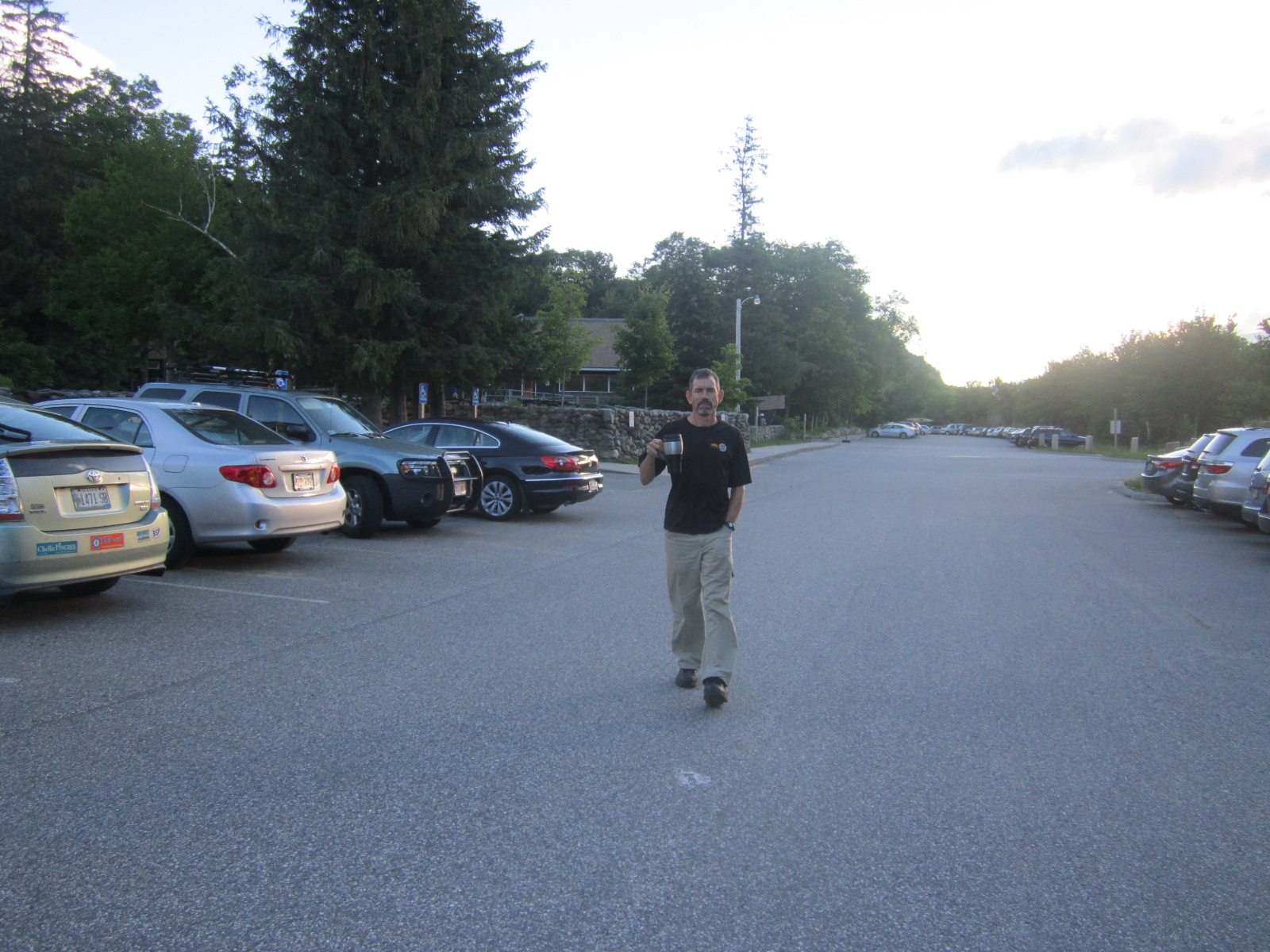
Maybe need a little more caffeine this morning... somehow, John can sleep here:

Beautiful cascade to start the morning:

Ah, sunshine!

We could see a big cloud blowing over the top of Mount Washington. It was quite an interesting perspective, with sun in the valley and a big white ceiling moving over us. So yes, we're heading up there...

Back there looks nice:

Up there - not so much:

Tuckerman Ravine and a really pretty bowl with water flowing down all the rocks:

Yep, still nice in the other direction:

It felt so much like Colorado, really a wonderful reminder of those mountains except we could breathe better here. I was very happy.
One piece of snow remaining - I always seem to locate a little bit of snow in July just for John :) I'm not so sure he appreciates it though.

Mountain flowers:

We climbed up above the bowl and into the cloud. It didn't take long before deciding we needed to don jackets and warmer headwear. The wind wasn't too bad on this side of the hill, at least.

We followed large cairns and climbed for a while in the mist.

Out of nowhere a car went by just above us - I guess we're near the top!

How did we get so close to the summit and not know it?

The experience continued as the wind hit us hard near the top. We climbed up to the summit sign and hung onto it to take some pictures, trying not to get blown away. I hope the sign is sturdy, I'm sure we're not the first to use it as an anchor:

Lots -- of -- wind ! ! !

Love this one:

We quickly found the entrance to the summit building and hustled in. Wow, that was something! Welcome to Mt. Washington State Park - the worst weather in the world.

Time for a hot chocolate warmer-upper, mmm:

John noticed this display of the wind speed - over 40 mph at that moment, 60 mph max in the previous 15 minutes (we might have been in it!). At least it was slowing a bit since the overnight hours. We were pretty excited to get to experience this. And then to come inside.

We hoped to hike over to a couple more of the presidential peaks along the ridge to the north. It wasn't certain whether the blowing mist would accompany us the whole way, but we decided to give it a try. Initially there was a lot of wind on the way down to the AT, then it let up a bit as we continued downhill. Crazy weather on the top of that mountain.

We heard rumblings and got to see the cog railway train come through - hello!

Goodbye!

We diverged from the Gulfside Trail to go over the top of Mount Clay and then along toward Jefferson. Eventually there was even a view below the cloud, nice!

Still windy, especially in the cols.

Practicing the Summit Pose:

On top of Mount Jefferson amid lots of rocks.

Rocks, rocks, more rocks. It was slow going but entertaining.
Look, over there - ?

Another nice view:

I believe this is heading down toward Edmands Col:

A cairn with a white rock on top - seemed to be the thing along here.

A nice look at the ridge ahead:

Climbing more rocks, this time up to Mount Adams:

The weather got nicer and nicer as we went along:

Looking at Madison Spring Hut and Mount Madison beyond it:

One last big climb up Madison, excellent climbing today.

I asked John, "so what do you think?" and he gave me this pose:


Whenever we got a glimpse back toward Mount Washington we would check it out. Most of the day it was still in that same blowing cloud. Right as we were on the way down the Osgood Trail off Mount Madison, we looked over to actually see the Mount Washington summit! Yay!

It was a long, steep descent, first down a rocky ridge, then down a narrow trail in the trees. I wasn't excited about it, and I was moving slowly, but eventually we got to the cutoff trail and things got better.
One of the many brooks in the Great Gulf Wilderness:

Nice bridge:

We followed the AT along the Madison Gulf Trail, over creeks and across some mud (but nothing too bad). The hike was taking quite a bit longer than I had guessed it might, at least we had carried some extra food and plenty of water (and there were plenty of water sources along the way). We crossed the auto road and even ran a ways on the smooth trail called Old Jackson Road.
Finally the notch and our truck. Wow, that was quite a day!
And I got to add another entry to our high points page:
http://www.kipley.com/marcy/highpoints/index.html
Subscribe to:
Comments (Atom)