For the first time I can recall, I was excited for a biking section. And better prepared than I've ever been. I'm not in my element on the bike, but my teammates are, and I knew they would help me out. Positive anticipation starting the first bike leg of the race.
Leg 5 - "Where Team Vignette makes a good move"
[83 miles of biking, 30% gravel/60% paved/10% "singletrack", 3300' gain and 3100' loss]
We arrived at the TA and got ourselves situated:

We had a decent transition onto our bikes, unloading them from their boxes and assembling them to ride. John timed my bike build, but I got distracted with gear stuff in the middle so it wasn't as fast as my practice runs, but still not too bad.

Tom getting hot water for a warm cup of something yummy:

Hello bike!

In the back of our minds we were always watching the clock, aware of the 72-hour cutoff at the end of leg 6, with another big trek in between here and there.

Apparently I sped a little too fast and Dave was asking if I could slow it down a little? Wow, that's a new one for me! I guess I was excited.
We paused at the ranger station to fill our bike bottles with non-creek water:

I also got to use a real (forest service) bathroom, such a luxury.
John caught us "in action" at the end of the gravel section:

Heading off across the high plains:

There he is again!

We rode on pavement for a few miles and got into a paceline. A tailwind blew us across the valley, and it might have been slightly downhill too, so we made great time.
I think that's a shadow of John standing on the truck to take our picture:

We flew out to the main road and continued our easterly cruise. Somewhere in here we were stopped by a race person to replace the tracker Leslie was carrying. There was one hill to climb on the way into Pinedale, and that happened to be where the mosquitoes were swirling. They started sitting on us, then Tom got bit on the butt (through bike shorts)! Worst mosquitoes of the whole race, not sure how that happened.
Normally we would have had nice views of the Wind River Mountains from here, but it was too hazy. Happily it didn't seem smoky where we were riding. It probably made for another nice sunset.
We didn't see that sunset, because it looked like we had time to stop at a hotel, yay! I had a timeline for when we needed to leave Pinedale, taking into account what I knew about the rest of the bike leg and giving us plenty of leeway for the second long trek. Even after wasting time on the nav error this morning, we made up for a lot of that with the quick ride into town.
So we started with a quick stop at Subway for sandwiches (no time for burgers at Wind River Brewing, bummer), and I grabbed a Tylenol bottle for a headache I was hoping to clear up. We were all motivated to move quickly and get ourselves fed, showered, and into bed.

We secured a room at the hotel next to Subway (super convenient), locked up the bikes in the "storage" area, scarfed part of our sandwiches and threw the rest in the fridge for later, and took turns eating and showering. I was so excited to brush and floss my teeth. Not sure why I didn't do that more often during the race (I should have kept the teeth kit closer at hand).
Soon we were all lying down for a 4-hour nap. Sleeping in a real bed, awesome!
I dreamed about navigating. Imagine that.
We all woke up just before the alarm, nice when that happens. I was a little slow getting going, trying to get my gear repacked so I could find things (after the waterproofing/stashing for the Snake River packraft). At least my headache was gone. Soon we were out the door and riding into the night.
Brief side note - John spent the night in the truck in the ranger station parking lot. Before he dozed off, he happened to see a moose with 2 young ones. How cool is that? I couldn't help including that photo here:

We stopped at the Visitor Center to find our next checkpoint. It was the middle of the night at the time, but John got a picture of CP4 the next morning:

We started down the road in a paceline. It was neat riding this stretch of road in the dark, one that I'd driven on multiple times so I had some idea what was alongside that we couldn't see.
John took a couple photos along here the next morning to show us what we missed. Lots of activity in the osprey nest, nice!

An excellent sunrise shot of the colorful alpacas (I think? Usually these kinds of farms have a big sign but in this case I have to guess):

We made the turn off the main road at Boulder and started along back roads going a long way east, then south, then east, a few more turns that Dave kept up with on the map.
Leslie kicked up the pace a notch, and without the tailwind to help propel me I couldn't quite keep up. After having to yell a few times to request a bit less speed, I finally asked if we couldn't just hook up the towline. Much better, thank you Leslie! I could stay in her draft most of the time, with an occasional tug from the towline when I lagged. That helped a lot for the uphills, and also the downhills when my whole team would turn on the gas and I would use the opportunity to stretch out my back and neck and shoulders and get off my butt instead.
Tom and Dave have loud voices and don't seem to mind when it's their turn to ask Leslie to ease back a bit. Leslie was on fire this morning! Even more so when we spotted a team up ahead, especially with Tom goading her on. Thank goodness for the towline. The other team had one guy up front towing all of his teammates, did I see that right?
We were looking for a side road to the left - here's the beginning of the next section:

Dave navigated well and we found our turnoff perfectly. There was a team sleeping on the side of the road there, and not for the last time we mentally congratulated ourselves for the rest in the hotel. It was a chilly night, perfect for the effort we were putting out but not great for a restful nap. We were also happy to see that we weren't in last place (having no idea how many teams had passed us back in Pinedale).
Time for some uphill gravel - and sand. Sometimes deep-ish sand, and a rutted road. It was slow going for awhile. We found checkpoint 5 at a bridge, then continued to climb to the east. We did some walking and I was happy for the break from the bike saddle. This bike leg had lots of reasonable-length stretches of riding punctuated by some walking (and stopping at a hotel!) so my bike butt handled it just fine.
I was anticipating getting to a spot that I knew. In the meantime, we followed the map plus some notes I had made based on Satellite View of this road/trail. All of the road splits made sense, with one brief pause at the start of a big field. The map suggested going to the right (bigger road) but my notes said to head north to the creek at that point, so we went north. That worked great and soon we were crossing Irish Canyon Creek.
I think Tom might have tried riding across, but I can't recall who or if anyone on the team made it without stepping in the water. I do know I got off and walked, that is certain. Wet feet, but not cold, no problem.
The trail along the north side of the creek turned quite rocky in places, so I rode what I could and ran when I had to. Dave stayed with me while Tom and Leslie did some good riding up ahead.
Following the creek:

Finally we reached the place I had been before during scouting, this split in the trail, yay!

I took all these photos during my scouting trek; it was actually nighttime when our team came through. We rode up and over a small saddle to the next field, when I started leading the way since I should be able to hit the turns that we needed to. The trail got less obvious in here:

For example, here's where you set off to the right across the field:

And most importantly, here's the split down the hill to the right:

Crossing a couple side creeks, I was pretty excited to know these landmarks:

Through the fence and onto the trail that leads up through the woods:

A less-obvious section of trail that turned real obvious after a bunch of racers went through, no problems following it here:

We knew we would be pushing/carrying the bikes up the trail for maybe a kilometer, due to the steep incline and a few blow-downs. My bike was heavy to lift with the loaded Pika seat bag on the back, but that was a fine tradeoff for having less weight on my shoulders the rest of the time. Thank you, Sheila and Sheila for that and other great bikepacking suggestions!

I was surprised to sense that there were fewer trees across the trail than the last time I was here, could that be true? It wasn't for sure, and there were plenty of trees still over the trail, but I wondered if someone had done some trail work in the meantime.
The top of the hill and bits of rideable trail:

Past the pond and a couple small water crossings:

Then we were nearing the edge of Lamreaux Meadows, except the racer tracks continued straight instead of hugging the trees to the left where the trail markers are:

I stayed on the racers tracks while thinking maybe that's not a great idea. Then when the tracks started hitting rocks under the beaten down grass I was really not pleased. Finally when the tracks seemed to continue almost straight south I was like, "nope!" Enough of that, time to do our own thing.
We hauled the bikes over to the edge of the trees and started making our way around to the left. The map shows a small trail, but I hadn't found one while scouting on foot. The grass was short enough to ride across, just a bit bumpy from occasional rocks.
It took a surprisingly long way before we saw a few racer tracks rejoining our route, I guess folks figured it out eventually. We found the next open area around when daylight started to gradually appear. We located a small trail, crossed a small creek, and rode up to checkpoint 6. Right on target, that was fun!
Last piece of map for this leg:


Turning south:

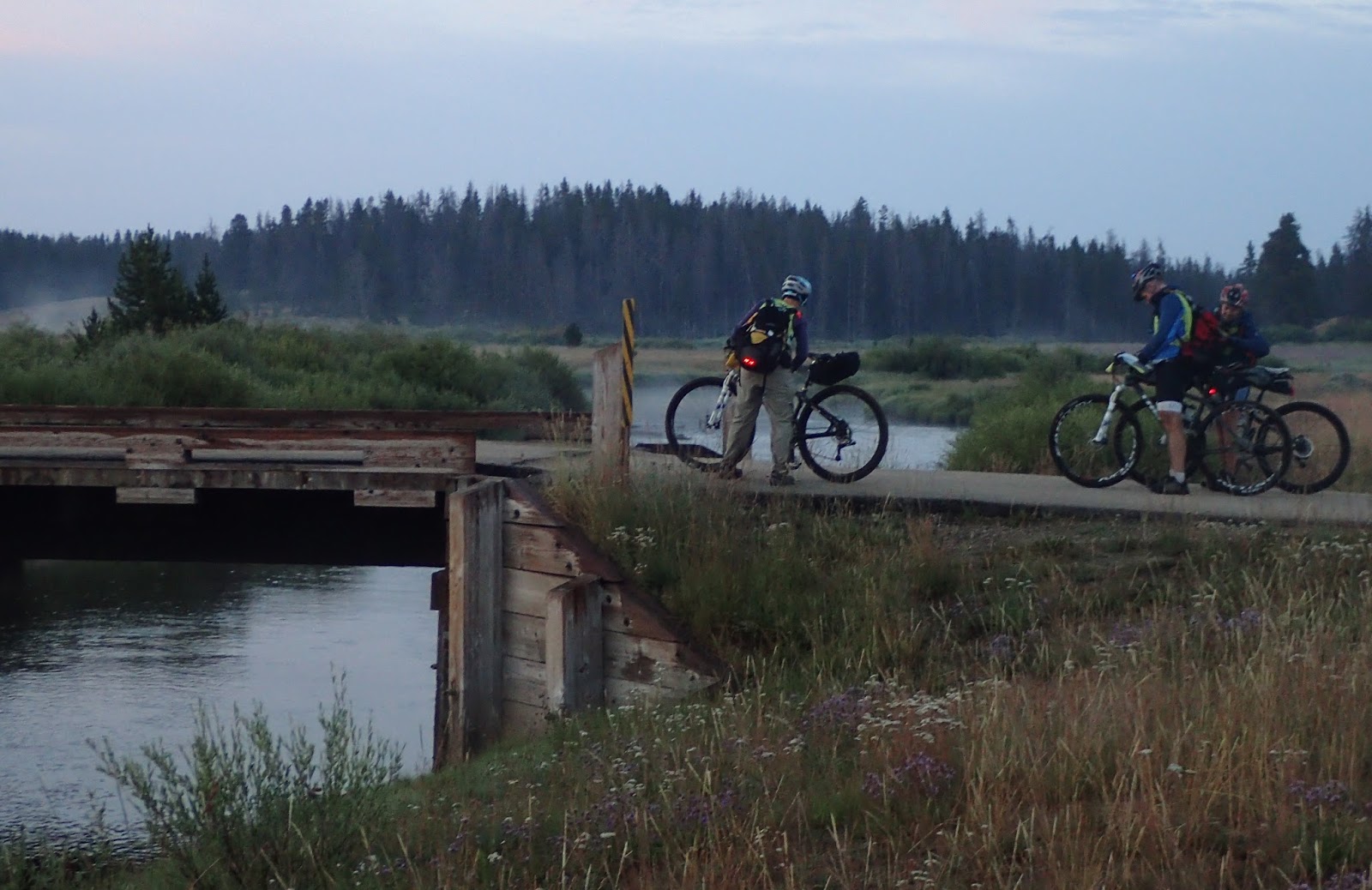
A brief pause at the bridge:
Another pretty view of the river and mountains in the early morning:

We hit the main Big Sandy dirt road, and I was feeling quite satisfied with my preparation for this section. We had a nice ride down toward the TA, crossing Dutch Joe Creek along the way (scouting photo):

We looked at a couple possibilities for the start of our next trek as we rode by, but couldn't make any real conclusions on the fly. No matter, we'd be back here soon on foot.
Boom, there's the TA right where I suspected - another scouting photo:

After leg 5 (bike #1, CP7) = 41:52:57, maintained 37th place
That went really well. Quite an enjoyable bike section, and I don't use those words lightly :) And we were well rested and ready to tackle the next big trek.
No comments:
Post a Comment