Being a short plane ride from Portland right now (and Portland being a short drive to the base of Mt Hood), we managed to squeeze in a quick trip. Happily, Timberline Mountain Guides found us an instructor for the first day we were there. Ben was an excellent teacher, helping us through all the steps of climbing a steep snow slope, using the ice axe and crampons, practicing self-arrest, showing us how to belay, all things we have read and talked about but not really had the chance to learn. We would get a lot of practice the next day, and we will continue to look for opportunities for more practice this summer.
The amazing mountain in beautiful weather on the day of our class (I idly wondered if maybe we should just start climbing then, except for the increased chance of ice fall toward the end of a warm day):

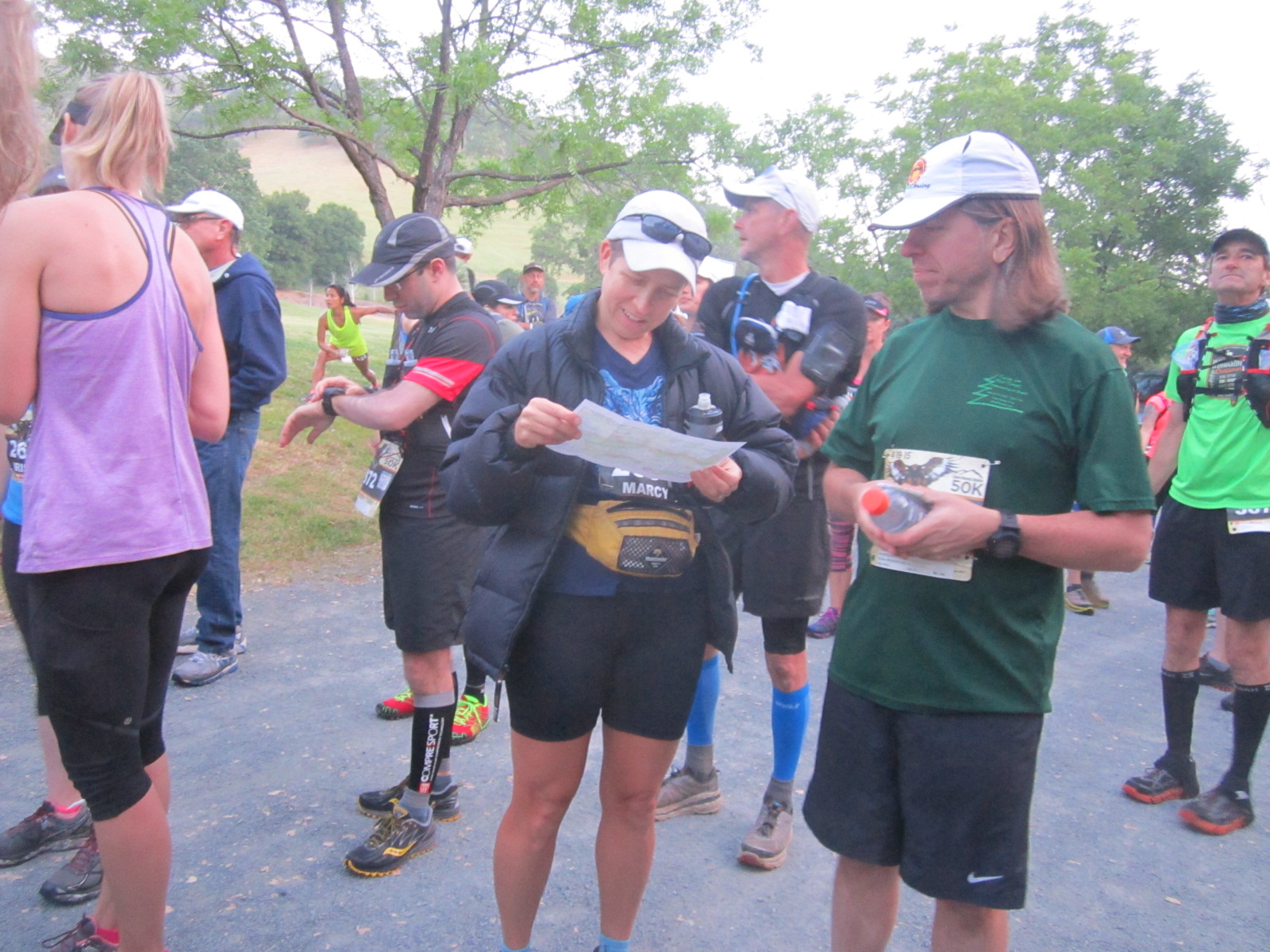
Learning the munter hitch as a belay technique (attached to a buried snow picket anchor):

Still gazing upward:

John at the end of his rope:

Buried ice axe as an anchor (with the rope going up to an ATC on Ben's harness) - and also, we'll be looking for soft shell pants like Ben wears on the mountain:

Our practice slope:

I'm front-loading the photos because once the actual climb started we couldn't see much around us the whole time...
The forecast seemed reasonable - some clouds, some wind, no precipitation until mid-day the following day. We had a good supper, took a nap, and got up to return to the mountain. Covered in warm/dry clothes and lugging more gear than we have carried in a while, we set off into the night from the lodge just after 1 a.m.
It was indeed a bit windy, but the sky was clear as we walked up beside the ski slope. We followed a groomer track, making good time compared to estimates even though it felt slow to me due to the clunky mountaineering boots and weight on my back. We had rented boots, plastic ones for me (insulated and warm) and leather for John (with extra-thick wool socks). They worked fabulously on the steep stuff, especially with crampons attached, but mine especially were unwieldy on mild/flat slopes. Almost like walking in ski boots, actually very similar to walking in ski boots with the bindings undone.
So anyway, it was nice having an altimeter near my face so I could verify that we were indeed making fine progress. We missed the location of the first hut (off to the side) but we weren't planning to stop there anyway. We could see lights from the groomers above us for a while, then below us, also some lights from town further down, but otherwise it was just dark.
The top of the ski slope was obvious, with a wide track cutting across the mountain. We followed it over to the Palmer lift hut and gained some shelter from the wind. As quick as we could we donned crampons, detached the axes from our packs, ate and drank a bit, and John threw on his puffy jacket under his rain coat. We were chilly by the time we started up again.
Everything warmed up quickly, and my fingers and toes stayed mostly warm the rest of the way up. Just a little wiggling was all it took whenever they got slightly cold. The wind seemed to be picking up, so our neck fleeces were quite welcome. All the Gore-tex outer layering along with fleece and poly pro under layering worked great and I was never hot (it wouldn't have taken much to cool down even if I had started sweating).
So we climbed some more, now on the slope above the ski area, aiming to the left and around the few rocks that we could see. I think John could see enough to figure out the right angle up toward Crater Rock, easily avoiding the edge of the glacier to the right. In any case I followed along and we continued to climb steadily. Somewhere in here we paused for a drink of water and managed to let the water bottle slip through our fingers - d'oh! It was long gone, skimming down the slope into the darkness. Darn it, hate it when we do that. It was indeed a good reminder to HANG ONTO everything.
We reached Crater Rock, actually it appeared quite suddenly as a dark face above us right as the slope got a tad steep. Circling around it to the right we found a nice snow bench someone had made and a bunch of tracks. Good confirmation that we are going the right way so far. The traverse was straightforward, especially in crampons. My first test of a steeper slope and it wasn't a problem, so I was happy about that.
Our first navigational challenge arose at this point. We needed to find several landmarks in here, but it was still dark - apparently we should have gone with John's suggestion to start closer to 2 am since we're decent uphill hikers. It was still dark at 5 am. We had studied maps and photos and route descriptions, listened carefully to Ben describing the route, and had maps, compasses, and an altimeter with us. It all seemed to suggest that we should find the Hogsback ridge somewhere around this flat area we were on top of.
We could see (and smell) a dark fumarole, so we went around it to the right and looked up the snow slope above us. Hmm, things aren't lining up exactly right but maybe this is it? We ascended the slope, getting in some good practice at least, until we could see above us that there wasn't an easy/obvious way up through the rocks.
Everything told us to go back down so we did, still enjoying our new-found steep snow climbing/descending abilities. Love the ice axe and crampons on the perfect snow - the snow condition seemed just exactly right (to our untrained selves), easy to kick steps into but not too soft.
Back at the flat spot, by now it actually was starting to get light except it was also blowing snow and clouds so we couldn't see any further than in the darkness. John wanted to verify that we were actually at Crater Rock so we backtracked around it. That seemed pretty clear, especially with all the tracks there.
Coming back around one more time, I could see to the right that everything funneled up a small drainage and then opened up into the small valley. No sign of the Hogsback, so we must still need to climb to find it. But where?
We investigated the fumarole more closely, this time finding the spot where all the tracks went uphill to the left of it. Ah ha! Let's try that. We followed tracks switch-backing up a steep slope and then gained the obvious Hogsback Ridge - as John said, it should be obvious, we could see it from the parking lot the day before!
Ben had suggested dropping down and across the next set of fumaroles here, but we couldn't make out exactly where that route would go. We spent some time discussing that and checking the photos I had brought along. I remarked several times that "it sure would be nice if we could see" until John finally said that we can't, accept it and move on. Good idea.
I wanted to climb up the Hogsback and then traverse over to the Old Chute (our intended destination all along), and John agreed that this made sense navigation-wise. Partway up the ridge there were a couple tracks angling off to the left so we followed those. We suspected, based on how far apart the prints were, that they were coming downhill, and they seemed like the best kind to follow since it was likely that person could see where they were going at the time and taking the straightest line.
Most of the tracks continued up the Hogsback to the Pearly Gates, but we didn't want to attempt that route. I had heard from a recent report that it was pretty icy in the narrow gully since this is a low-snow year, and someone had tried it without ice climbing tools and wasn't comfortable about it. Ben's instructions to use the Old Chute confirmed that for me.
Through all of this I wondered at what point it made better sense to turn around and give up on the route finding, but it was such an interesting puzzle and we kept making progress. Plus we were plenty warm, had lots of supplies and time on our hands, and nothing indicated any impending problems. We could always see at least several meters in front of us, usually more like 50-100 meters, so it wasn't a complete white-out. Just a good challenge. Continue onward and upward then!
After clearing the bottom of a rock face that we could see above us, we started up a slope that we hoped was the Old Chute. It continued to stretch out above us as we climbed, at least as far as we could see. Everything made sense now, so hopefully we were right.
John slowed his pace so I could follow right behind him as the slope got slightly steeper. We angled upward one way, paused to make a turn, then continued upward the other way. I focused on using what Ben had taught us - two points of contact (out of 2 feet and one ice axe) at all times, good solid steps, move deliberately, use the rest step. stay in a position of balance, good posture. Not being able to see below us made everything pretty easy, actually. I enjoyed it quite a bit, focusing on what was immediately around me. Aside from the uncertainty about exactly where we were and not being able to see much.
The wind continued to blow, depositing rime ice on everything that was exposed. Slowly our clothes turned white, the top of the axe turned to ice, John's eyebrows developed a white curly-cue, and everything outside our packs eventually got coated. Flashbacks to the top of Kilimanjaro, especially the ice coating Kip's hair at the time.
As it got steeper, John started kicking steps into the slope. He would spend a few seconds on one step, move up, and I would follow along kicking the step deeper. By the time both of us were done with a step, it was in great shape and I could stand on it easily with my whole foot. Nice work John! I kept telling him that what he was doing was awesome and so helpful. The snow was just right for being about to do this, wow I can see how this could get to be addictive especially for someone like me who generally has problems with travelling on steep stuff. I especially loved having a solid handhold on the axe that was plunged into the snow next to me.
We saw shades of footprints here and there, giving us confidence that we were probably heading up the right way. The blanket of white continued above us, with a rock face to the right and another starting to appear up and to the left. It was never absolutely certain that we would top out up there, but neither was it obvious that we wouldn't. If nothing else, we were getting in some excellent practice. I had never committed to reaching the top "no matter what" and was quite happy that we had made it this far.
The slope got steeper and John had to work harder with the steps. Still I was in a good frame of mind, more comfortable than I thought I would be. We were staying warm from the work, still moving upward although quite slowly now.
Near what we suspected might be the top, someone had front-pointed some reasonably deep steps into the side of the slope. We decided to try following them. The snow surface was less thick here, but we still had plenty of purchase with the axe and crampon points. I wasn't quite as happy for a couple minutes, but that's all it took to reach a section with a bunch of wide steps and benches from previous climbers. We must be in the right place. And I made it all the way without a belay!
A couple things happened - the wind whipping across the top ridge was pretty fierce. Also, the transition to a gentle slope turned out to be awful on my lower legs. The mountaineering boots were the absolute bomb on the steep terrain, but they were killing my shins when walking on a "normal" surface. I couldn't flex my ankles at all, and leaning forward into the boots eventually put a lot of strain on my shins. Ow, ow. Not sure if there is any way to improve that, but I might have to try John's strategy of wearing leather boots with thick wool socks next time.
So I followed John rather gingerly across the ridge and we found a bunch of footprints leading over to the summit. Despite the ridiculous wind and me not being able to walk very well, we easily made the short traverse and then we were there! Woo hoo! I was happy to recognize the area from other summit photos (the ones in sunshine) so we didn't need to poke around to make sure we were at the highest point.
Now how to take a summit photo? And how to get it done quickly and get the heck back down into a more sheltered spot?
I wrangled the camera out from an inner pocket but it wouldn't turn on even though it had been hiding in a reasonably warm place. I found out later that I had put the battery in backwards - d'oh! One of my only small (non-navigational) errors on the day. It was not something I could conceive of fixing at the time, put it away. I pulled out my phone and it had plenty of battery, yay for a phone that doesn't mind coming out in this weather.
As quick as I could I snapped 2 pictures and later could not believe how well they came out. Seriously, best summit photos to date, even though you can't even see the mountain:

Even managed a selfie without using the front camera - I had no idea if this one "took" but we would have to wait until we got down to find out:

Side note - I had seen photos from other reports of people climbing in broad daylight still wearing their headlamps, and that had struck me as funny at the time. I officially recant my snickering. There was no way we were stopping to remove our lights from beneath our helmets AND stash them at any point during the climb. Just not happening.
John fished out the Spot tracker that we are borrowing from Sheila (thank you Sheila!!) and hit the "OK" button to get out the message that we were at the top of Oregon!

As far as proof that we were there, that's all you get. It's not like there's a prize for this highpointing quest, in any case. Besides really enjoying ourselves so far!
OK, we gotta go. We managed to start along the wrong ridge heading back, not EVEN sure how that happened. We figured it out quickly, but sure wondered why we ever thought we were capable navigators, geez. Not being able to see but a few feet forward can be quite a challenge in the mountains. We could always see directly in front of us and were never in danger of missing a drop-off right ahead. But we didn't linger long to wait to see if that might ever change.
Back at the top of the Old Chute, we quickly discussed the fastest way down. Especially for the steep part at the top, it was clear that I would move a lot more quickly if I were on a rope as a backup. John was completely good with this idea, pulling the rope out and setting up an ice axe belay. We managed to get all the knots in place, and we were extremely happy that we had both decided to climb (from the beginning) wearing our harnesses even though we hadn't used them up to that point. Way easier than trying to pull them on in the howling wind.
John stood on the axe while I tested out the rope - everything looks and feels good. He slowly lowered me and for this first pitch I leaned back into the rope like a simple rappel. It was steep enough that I was really glad we had decided to use the belay here. I found a good ledge, set up some steps and a good ice axe hold, then signaled to John that he could get off belay.
John down-climbed to me and we repeated the process. In fact, it was working so well that even as the slope lessened to where I was easily walking downhill, we continued to use the belay since we had it set up and it was simple to continue to use. I'm pretty sure that overall we moved way faster than if I had been doing it without protection. We took turns getting a little cold waiting for the other, but it was never too bad and we would warm up quickly when we got moving again. John ended up with a sheet of ice on one side of his face from standing in the wind for the top 2 pitches, that was pretty funny to see and thankfully not problematic.
At some point we finally realized, you know, we're carrying SKI GOGGLES, we really should be using them. That helped a lot just to keep our eyelashes from icing over and reducing our field of vision. Next time we should realize this sooner. Being off the top ridge helped a lot but it was still windy.
We debated dropping all the way down to the bottom of the slope to take the route Ben had suggested, but I was thinking that navigation-wise (which was really the important factor at this point) we would do better traversing back over to the Hogsback. We continued to pass below each rock face to the left and eventually we could see the bergschrund (a gap at the top of the glacier) - cool! Right below that we hit the Hogsback ridge and the superhighway of tracks. It was actually briefly calm and quiet here, how very strange.
John stashed the rope and we started down the ridge, my shins complaining again on the easier slope. Just can't win with these boots. We had no trouble retracing our steps down the side of the Hogsback, through the Devil's Kitchen (now we know what that area is called), and around the base of Crater Rock.
From here we knew that it was super important to follow a bearing of exactly south. The fall line (where something, say a water bottle, would go if dropped) led off to the side and into some steep territory that we didn't want to get involved with. The ski slope was exactly south of us, which meant we would be angling left down the slope. We had both paid close attention to these instructions "in case of a white-out", and we weren't messing around with this one.
It was a long, long way down. We could see nothing, just white in all directions. It still wasn't a complete white-out since we could still see 50-100 meters ahead, but there was nothing to see but snow. It eventually played tricks with our vision. We both swore at separate times that we could see the ski hut, but it always turned out to be a big rock. I watched the altimeter like a hawk, wondering if we possibly could be going down so slowly? Yep, we could. It's just not easy walking downhill in mountaineering boots and crampons.
John at one point wondered why something was floating - turned out to be a ridge of rock over a white surface. He started another way thinking he saw the hut, but finally gave up and just kept on the southerly bearing. White blowing wind, white snow, no sign of progress but we kept on trudging.
Finally a dark shadow appeared that had straight edges and a triangular top - that's it! We dropped down almost on top of the Palmer Lift House, nice southerly bearing, John!
We paused to remove the crampons, eat something, and stash the ice axes. I loosened up my boots as much as I could, which helped my shins from getting further beat up but they still hurt while walking. We initially started along the top groomed track over to the eastern side of the ski slope, but when it wasn't clear where to drop down from there, we returned to the lift and decided to follow it down. After all, it was almost a white-out, and the white-out instructions were to follow the lifts.
So our nav challenges were done, just walk down and watch the numbers on the lift poles. That took even more forever. Partway down we met a guy hiking up who was considering a climb but he said he was probably going only to the top of the ski slope. It was great meeting a real person for the first time in hours! We aren't completely positive (since we couldn't see much of anything and there are multiple ways to the top), but we suspect we were the only ones up on the mountain that morning.
More downhill slogging, I won't bore you with details because honestly there aren't any. After a long time we made it down. Thank goodness! Boots = OFF!
We thought we might get cold quickly at the bottom, but found that all of our clothes beneath the outer layers were completely warm and dry. We did shed a ton of ice and snow from everything that had been in the wind - off our helmets and packs (including pockets), jackets, gloves, harnesses, altimeter, dangling whistles, oh yeah and the headlamps still on our faces, goodness that's a lot of extra weight we have been lugging around.
One last set of photos from when we finally reached the lodge:

Happy to be down!

The weather at the bottom was still crap:

Now for a return to "normal" with the glow of having actually reached the top and returned without incident.
And happiness at having rented a yurt for 3 nights - loved it!

Well, that's the (very long) story of highpoint #28!
http://www.kipley.com/marcy/highpoints/index.html
Total distance = somewhere around 7-8 miles, total climb/descent = 5300 feet, total time = over 12 hours (after getting to Crater Rock in about 3.5 hours, well then)