[Awesome photos courtesy of GMARA]
I'm lucky I was able to race all 3
GMARA races this year. Frigid Infliction was great fun with Laurent, Murky Excursion was a blast with John, now I get to race with both of them at once. Cool!
Welcome to Moosalamoo National Rec Area in the Green Mountain National Forest!
Welcome to the Blueberry Hill Inn - we stayed here and absolutely enjoyed it from start to finish. Highly recommend it!
A bottomless jar of chocolate chip cookies, plus they made pre-race breakfast especially for us at 4 a.m., for goodness sake:
Then it was time to get serious with the map:
The race started on foot with 3 checkpoints in the middle of nearby ponds that we could get in any order. We started with CP1 to the north, jogging up the road and having way too much fun:
When I say "in the middle of nearby ponds", the key words to know are "middle" and "ponds".
Another team caught on camera approaching CP1:
And the checkpoint itself - yes, the orange thing way out there:
It's odd, just the week before the race I was thinking I need to do more training with wet feet to prepare for a fall race. I guess the GMARA guys heard and decided to grant my wish.
Wet and blurry, on the way back past the start/finish on the way to CP2:
We ran up a trail and a short way through the woods to locate our 2nd pond and checkpoint:
Back down the hill and across the way to a dirt road leading to the area around CP3. It was quite a swamp, as we waded in other teams' footsteps around to find the checkpoint. A direct northern route provided a dry (and faster) path back to the road, save for a creek crossing.
We returned to TA to celebrate my fastest first 3 points ever in a GMARA race!
Time to pick up our bikes and head away from the Inn for a few hours of fun.
Team Untamed New England had already departed, and we joined the chase pack with other high caliber teams including Checkpoint Zero and the NH Trail Vets. My only real goal for the race had nothing to do with competition, however. One week after running the Vermont 100, my legs were still recovering. I just wanted to focus on the navigation and try to hit the CP's as cleanly as possible.
I should have added an addendum of "not make any major mistakes", but that explanation would be getting ahead of myself.
In the meantime, back at the race, we biked up the road and found the turn-off onto a doubletrack trail for a bit of fun downhill riding. At one point we were told we had to walk our bikes for a certain section:
One of the largest rootstocks we have ever seen - very cool that GMARA took a photo of it:
CP4 partway along the trail - we didn't have to get our feet wet for this one!
A bit more riding, a couple junctions that we navigated cleanly, and we were at TA2/3 and the bike drop.
Getting prepped for a long trek, we copied the location for CP11 (the ropes section) onto our map and got our stuff together quickly. As we were leaving, I told John I had not yet looked at this section and had not made a plan of attack yet. We quickly scanned the map for the 8 checkpoints and decided to aim for the ropes first, just in case we could beat any waiting lines that sometimes happen with ropes sections.
Anyone familiar with this race course and instructions is probably saying right now, "You doofuses", but we'll let everyone else keep guessing as to why. Let me just state up front that I was the one carrying the instructions.
On the way to the ropes, we started with CP5 up on the hill across the way. A couple other teams were with us as we scrambled to the top and followed the ridge up to the checkpoint.
From there we turned and headed north down along the ridge. Partway down we came out at a powerline cut and were rewarded with a brilliant high-level view of Lake Dunmore to the west. We had to pause for a moment to properly appreciate this beautiful early morning sight.
Continuing down, we were careful with the altimeter but upon sighting the huge water tower above CP12, it was clear that we weren't going to overshoot this one.
From there we followed a dirt road around to the north and then dropped down to cross a creek and find a trail on the other side. This led down to a camping area, a few big rocks, and the
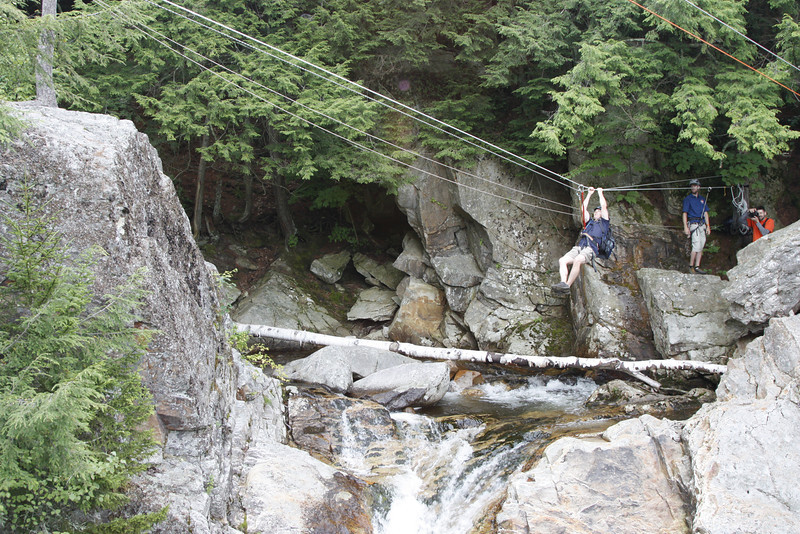
Petra Cliffs guys who were hanging out and testing the tyrolean traverse across the water. They were surprised to see us, as they thought the first team would arrive an hour later at least. None of us could explain it, but they were happy to suit us up with harnesses and helmets for a short and quick traverse above the Falls of Lana. Very cool!
No cameras while we were there, nor a CP flag (the guys signed our passport for us instead). Here's what it looked like a bit later:
Thanks y'all!
Back on the trail, we followed it up to a confluence in the creek and then up to CP10 nearby. My Vermont100 legs seemed to be holding up OK, not in sprinting shape but fine for an adventure race trek in the woods.
We departed ways from the mapped trail after CP10, but there was still something of a path to follow next to the creek up to the area of CP9. I had a bit of an issue deciphering the edge of the hill (a rather steep drop-off over the creek) vs. the contours (suggesting a more gentle slope) so we lost some time looking too low on the hill. Eventually we figured it out and found CP9, noting another team leaving it as we approached.
We thought it was odd that this was the first team we had gotten even a brief look at since CP5. Everyone else must be doing this loop in the other direction (answer: almost everyone, yes).
My original intent was to follow the stream up from a pond to CP8, but there was a nice road heading uphill to an even nicer road, so we decided to go around instead of trying to stay low near the water. We moved quickly along the road/trails, but this backfired a bit when we missed a turn down to CP8. The somewhat overgrown trail we were following didn't match with the map. Eventually I got antsy enough about the distance that we turned and cut down to the creek and then followed it downstream to CP8. Argh, 2 CP's in a row with some lost time.

Back uphill to note the spot where we should have turned down, then uphill cross-country to the main dirt road. The next trail down to Silver Lake was very nice so we tried to jog a bit and start planning for the swim portion of the race. We had not realized just how much of an actual event the swim would be, so we were rather under-prepared for it. Next year maybe we'll even practice for it. One time, anyway. Or maybe there will be canoes instead :)
Down at the lake, we looked across at the 2 buoys WAY over there and WAY that way. OK, this was going to take a while. The water was warm and we floated in our PFD's, relaxed, and tried to keep going in the right direction at least. Not our strongest showing. Laurent did great and John and I tried to keep up.
A lady on a standup paddle board came out to chat with us, keep us company and take pictures. That was really nice.
No wonder it took us so long, we were apparently just hanging out and having a party :)
Pretending we were inspired by the Individual Medley in the Olympics...
I swear we weren't just clowning around the whole 30 minutes...
We finally got both CP's and dragged our soggy selves back onto the bank. Dripping, we ran back north along the lake. Along the way we passed a couple of campers, and one of them saw me holding the map and asked if I was the secretary? That elicited great laughter from the guys and made for a fun story later. Apparently they think I'm the CEO.
Back to the TA to collect our bikes and continue to the next section. Several other teams were also transitioning to bikes, so we hustled a bit to get out first. We knew we had lost some time to the lead teams on a couple nav errors, but did not realize the full extend of our "interesting situation" yet at that point.
The bike trail up and along the top of Chandler ridge was one of the more interesting and technical trails I've ridden in a while. Good practice for riding around/over rocks and roots and knowing when to just get off the bike and run. Some of it was easy and some of it was actually fun (John enjoyed it more than I did). We collected CP's 13 and 14 along the way, then rode a long downhill that went surprisingly well.
At the bottom there were two trail intersections, and we briefly explored the wrong way at both of them, but at least we took no more than a couple minutes each time before figuring it out. Let's just say the trails on the map are no longer exactly correct.
Coming down to the last TA/bike drop:
One last trekking section awaited, with one required checkpoint and 3 optional ones for a 1-hour bonus apiece. We thought we would have time for the 3 bonus points, assuming we didn't make too many nav errors.
Prepping SPIZ in a baggie and checking out the map:
We started with a jog up the trail toward the one regular point, trying to avoid the stinging nettle that encroached from both sides. We were only partly successful, and I was really close to stopping to dig out my orienteering pants. CP15 was on an "Awesome Rock" and as we scrambled up to reach it, we had to agree. Very cool moss-covered giant rock pile.
Time to climb up a steep hill toward the 3 bonus points and just as importantly, away from the stinging nettle. With a bit of work we reached the "Ridge Trail" on the map. Another team was coming toward us, but they stopped after we crossed paths. Right about there we should have found another trail going east, but there was nothing even close to a trail anywhere in that direction.
So this is how it's going to be. Recalculating... time to ignore the trail on the map and play with the contours instead. We climbed up to the top of the ridge and searched a short ways before I found the checkpoint just off the side of the hill. Score!
Back down to a bit of a saddle and then we actually did find something that might have been an ancient path. Since it was slightly easier walking than in the woods, we followed it around as it went east and then south like it was supposed to. I pace counted for a while until it was time to move off to find a couple little drainages.
There were two drainages that would converge just above the checkpoint, so we followed the second one just to be sure we were far enough to the east. Sure enough, there was an intersection and then there was the 2nd bonus point. Awesome.
I was less sure about the approach to the final bonus checkpoint, so we took a careful bearing and altitude check. Then we started the process of drainage hopping until it was clear we had reached the edge of the main ridge above our bikes and CP15. It wasn't easy to read contours in the dense woods, but Laurent's altimeter suggested we were somewhat below the CP even though I thought we had aimed off above it.
We decided to trust the altimeter, and after walking just a short ways up the ridge, John spotted the checkpoint flag. Phew!
From there we ran downhill, quite pleased with ourselves on that loop. We told Laurent that it was similar to the nav from the Murky Excursion trek, and he asked how that had gone for us. We replied that it went great until we got lost trying to find our bikes again... hmm, I guess we better keep focusing on where we are going right now then!
Happily, we had no trouble finding our bikes this go-around, and we greeted the TA folks with smiles. The results show that we had a stellar trekking loop, coming close to the fastest of the pack with only Checkpoint Zero ahead of us by 4 minutes for the split.
Time to ride on home!
That didn't end up being quite as easy as it sounds, as we were pretty close to the lowest point of the course and the finish was quite a bit higher up...
We found CP16 as we headed up the start of the climb, then continued up and up. My legs began to fade, so John towed me up the steepest part - thank you! Near the top we spotted a team ahead of us, dang it, now we had to try to race. Plus there was a dark cloud and then it started sprinkling.
Everything pointed toward getting to the finish line faster, so we kicked it up a notch and flew down the road with all we had, passing the team and continuing to ride fast. A crowd greeted us as we rode right into the finish tent to get out of the rain as quickly as we could. Mom and Renee and Laurent's wife and kids and parents were there to root for us! Thank you all, that was a marvelous cheering section and a super finish! It was great to see everyone there waiting for us.
Then we finally got the bad news we had been oblivious about all day. It also explained so much. The middle trek (with the ropes and swim) was supposed to be done IN ORDER. My bad for not reading the clue sheet instructions. Many, but not all, of the sections in GMARA races are rogaine-style, so I just made an incorrect assumption and didn't take the time to verify it.
We would have gotten
third place in the co-ed division without that mistake, bummer. On the plus side, we had a fabulous experience and thoroughly enjoyed the race. My teammates don't seem to hate me for it, so hopefully we'll have another shot at redemption at future GMARA races together.
I was one of 4 people who raced all 3 GMARA races this year, cool! Keeping good company with some fine folks:
Thank you all!
And thank you to the Blueberry Hill Inn! We plan to return in the winter for some cross-country skiing and some time in the sauna!