Hello friends and family in Blog Land! John and I had an amazing and extended summer, and I look forward to writing more about it. Maybe I'll get closer to catching up to "now" in the near future, who knows.
One of the big highlights was spending a week in southwest Colorado with Robyn in early July. She had suggested day hiking the Hardrock 100 race course, something called "Softrock", and I was all in for many reasons. It was great training and gear testing for UTMB, a chance to spend time with a friend who laughs at my jokes, and an excuse to see the incredible scenery of the San Juan's again.
Plus John got to drive our new Rivian (named Tug-E) around the Colorado mountains, even taking it over one of the easier dirt road passes on his own adventure.
We met up in Silverton for a "let's get this party on the road" meal, camped at South Mineral Creek, and got moving early the next morning for our first big day.
The key word being "big" - we had both recently had covid and Robyn hadn't been able to train as much as she planned, especially at altitude. I promised we would take it slow.
(Photo credit to Robyn and John)

It was fun seeing the (new to me) Hardrock rock in town. This older one at the first trailhead might be the one I kissed at the end of the race in 2011:

We got into a hiking groove along the first up/down trail (heading counter clockwise on the loop course), did our first water crossing, and then started the first For Real climb of the day up toward Dives-Little Giant. Admiring the rock colors and the first of many, many old mining sites we passed:

I managed to miss my first turn of the week, taking us accidentally to the lake before realizing my error. Being the adventure racers that we are, we decided to scramble cross-country up to the trail. No problem, just a bit of extra steep climbing effort.
The section of mining road we probably were supposed to bypass on a trail higher up:

Robyn never complained, nor said anything like "what have I gotten myself into?", although it might be visible on her face...

A quick run down to the location of Cunningham aid station, another water crossing, and the start of the climb up the other side. We were thankful that it didn't rain the entire day, only parts of it. We did a short detour to treat water from a side stream before continuing uphill.
My next mistake was forgetting just how high we had to climb out of Cunningham. I have vivid memories of PIECES of the Hardrock course, I've forgotten many details, and I suspect I blocked out a couple parts that I didn't care to ever think about again.
Before we realized how much work we had ahead of us and how long it was going to take, Robyn was still smiling:

It is such a gorgeous place, and with barely any snow on the course it was relatively easy travel. Except for all the uphill, of course!
I couldn't remember where the trail topped out, and I was rather taken aback every time it turned uphill again. Robyn had figured out by then that whenever there is a choice, the trail WILL go in the more difficult direction. We took it slowly, took breaks to recover, and eventually found the broad saddle near Green Mountain:

I had called the rest of day 1 "rolling" and this was error #3. Apparently I had been sufficiently trained for climbing at high altitude in 2011 that I thought all of these climbs (which I now label "significant") were no big deal. Sorry Robyn!
We did several off-trail sections and I was glad to have a track on the Gaia app to follow. We got a good taste of what Hardrockers consider to be "normal" that first day. A faint animal path? That's a solid Hardrock trail. Straight up or down the side of the tundra? Sure, why not. Yep, it was starting to come back to me.
Midday sunshine and two wildly differing expressions, as we crossed over the Colorado Trail and quite possibly the Continental Divide:

Robyn led the way down the long West Fork Pole Creek drainage, we muddled our way over to the next trail (I think this part of the race was recently rerouted, which I didn't read until later), and we started up Pole Creek proper.
I thought I saw John waiting for us on the hillside, but it turned out to be a signpost. Yep, apparently I think my husband is a trail marker. Or vice versa.
I was a bit concerned about the section of willows that I remembered near the saddle, but the track took us in a different direction. Higher and to the right - ? More Colorado Trail signs, a view of Cataract Lake from a spot I hadn't been to before, and finally I got the lay of the land and figured out what was going on. No more willows to thrash through, much easier to follow, just some additional vert.
By this point the wind was really blowing and daylight was waning. We got a move-on across the wide open tundra, getting rained on at some point, and then spent forever doing little creek crossings and trying to figure out how much further we had to go. Robyn didn't quite have enough clothes so she was eventually quite cold and quite ready to be done for the day.
Still she didn't complain. I caught sight of a rainbow behind us and encouraged her to turn and look, so pretty! Her look suggested that this was not the time for admiring such things. My hiking pole happened to snag a little flower on the end of it, and I couldn't help myself - look at this, Robyn! She might have bitten her tongue trying not to yell at me for stopping our forward progress while she was so cold and tired. We laughed about it not long later, and now I have another "Rainbow!" story with another good friend.
Finally we reached the descent down Cataract Gulch, and wow, this was definitely one of those sections I had completely and utterly blocked from my memory. I had envisioned running down beautiful switchbacks and flowing down to the bottom. Um, nope! Rocks, steep drops, and many, many challenging creek crossings.
It was dark by the time we saw John's headlight coming toward us, yay John! He was carrying a fleece jacket that Robyn was so happy to put on. We continued working our way down, and it turns out that the last few hundred meters of descent are indeed a couple beautiful switchbacks on flowy trail. We didn't care by that point.
We were so thankful that John had found a nice spot for our tents, set everything up for us, and made it super easy to get changed into dry clothes, eat some hot food, and snuggle into sleeping bags for a solid night's sleep. Not to mention the long drive he made from Silverton around to Sherman. Thank you John!! What a Super Crewman.
The original plan was to do another long day and then have a rest day in Ouray. Adjustments were made and rest day was canceled in favor of 2 half days. That turned out to be an excellent decision, giving us recovery time on the morning of day 2 and much less stress about climbing over Handies Peak.
Another benefit for Robyn's recovery and altitude acclimation was that John could give her a ride up the next road to the trailhead. I opted to run it and get in some additional miles, meeting up with them to get my hiking pack so Robyn and I could continue upwards on the trail.
John was doing recon to determine whether the drive over Cinnamon Pass was feasible with Tug-E. That would save him a bunch of time on the roads, especially since we would be stopping for the day at Grouse Gulch instead of Ouray.
For our part, Robyn and I had a lovely walk up into the upper basin, thoroughly enjoying the sunshine and beautiful weather. We got a late start, as 14ers go, happily that didn't turn out to be a problem that afternoon.
Robyn taking pictures of flowers:

Such lovely columbines!

Climbing up into the rocky section - I always prefer this direction over Handies. Last time I was here I was racing an evening storm. Much better weather today:

Yay for the scenery! Robyn managed her upward effort, making slow and steady progress up her first Colorado 14er:

John's view on the way up to the pass - looks pretty straightforward for our new truck:

Well done, John and Tug-E! You made it up to 12,640 feet:

Well done, Marcy and Robyn! We topped out at 14,058 feet and met a couple new friends who took our picture with the sign:

We had a fun conversation with the two guys about crazy trail races (UTMB, Tor de Geants, the High Five 100), then it was time to head toward American Basin.
Normally the basin is filled with snow in early July, but not this year. Looks like smooth sailing across this beautiful landscape (nice picture, Robyn!):

We stopped for a food break at the lake (the advantage of not doing this like a race), then started up the other climb of the day. Then there was John, excellent!
He accompanied us over the pass and down the long drop to our camp spot. We had fun telling stories along the way:

We were so pleased that John made it easily over the pass in the truck and that he found several options for camping (since I hadn't done any pre-work to try to answer that question). It was great finishing in daylight, especially for this sunset view right before we dropped off to sleep:

After one of the quieter July 4 nights (no fireworks anywhere near us!), we awoke early and got ready for our one climb of the day. View of our campsite from the dirt road across the way - thank you Tug-E and tents and I presume John is over there somewhere:

Robyn has her Happy Face on today :)

Checking out an old mine access point right next to the road - Robyn declined to crawl in even though the door was unlocked:

The climb up to Engineer Pass was filled with chatting and passed quickly. We were both getting our mountain hiking legs under us, and I cannot begin to thank Robyn enough for this excellent week of training as UTMB prep. Super helpful - and fun!
It started sprinkling as we descended into the Bear Creek drainage, time for rain clothes!

One last picture before I put the camera away in a waterproof bag for the afternoon:

It had been a good call to start early that day, as there was a brief spell of thunder/lightning, and we were already quite a ways down the hill when it passed over us. Then it was just rain, and this time both of us had the proper clothing to handle that.
Partway down we crossed paths with ~3 runners who were running uphill, quite impressive. They were wearing European shoes and kits and I wondered whether they might be here to run Hardrock. They disappeared too quickly for us to inquire.
We had "fun" with the exposure and side drainage crossings toward the bottom of the trail, always an experience through here, ever mindful of our steps. It's a lot safer than it feels...
Even the switchbacks above Ouray had a couple interesting challenges, most notably a small waterfall pouring directly over the trail - I've never seen that before! Rain sure creates some curious phenomena.
John was parked at the spot where the trail crosses over the highway to make sure we didn't want a ride into town. Nope, we're good, thanks! I happen to get a kick out the fact that the trail was built right over the road tunnel, but Robyn was less than impressed. Or maybe she was just over the whole rain thing.
The little trails down to town were as annoying as I remember, going down and up and this way and that and never getting on with the business of helping us make progress. Finally we found the road, where John greeted us again:

One minor wrong turn, a quick fix (thank you Robyn for your patience!), an easy run down into Ouray, and eventually we ran on in to the park where the race aid station is located. Another section completed, yay!

A warm shower and Howie-cooked meal was too tempting to pass up, so we drove over to Montrose where our travel trailer was parked in a campground. We also popped into a gear store that amazingly happened to have a pair of waterproof overmitts for Robyn (on sale even) and over to the grocery store for supplies. It was great to be dry and warm (and indoors) for a little while. If only the highway noise weren't so loud for Robyn in her tent - wilderness camping does have its advantages (as does a hard-side travel trailer).
Anyhoo, we were in good spirits the next morning. Sunny day and back on schedule, and another "half day" with only one climb planned. It was a big one, mind you, but easier to deal with than day 1's shenanigans.
I made it more difficult than necessary to get out of town, taking a wrong turn and taking too long to check my phone map to figure it out. Eventually we returned to the race route for a fun walk over the canyon bridge (love it) and on up to Camp Bird Road.
John was spotted as we started walking up the road - he was hoping to do the Ouray via ferrata course that morning. We found out later that the ranger told him our equipment was insufficient (even though it comes from France/Italy where they invented this sport). Bummer, another time perhaps.

It was a lovely morning for a road walk. More beautiful views on the long way up:

After hiking up the 4WD section, we watched a tall, fast runner bound down the trail toward us. We realized we had seen the same guy running in the rain yesterday, so we said something to him about it. He was French, and friendly, and we chatted about Hardrock and UTMB. Pretty sure we just had a chat with Francois D'Haene, so cool! What a great ambassador for the sport.
Time to get moving toward Virginius Pass. Robyn was aware by this point that a scree climb was in our near future and she was a bit concerned:

We worked our way up the first section, a good little warmup. The poles helped and we found places to scramble up to and rest in between short bouts of exertion.
Making progress and admiring the colorful views:

That was fun, Robyn, shall we continue upward?

We could finally see what the fuss was all about - a steep dirt and rock-covered slope, not a bit of snow except at the bottom. That's different from what I'm used to seeing.

A pile of bones, not ominous at all...

We got to work on the upward scramble, putting all our effort and adrenaline into gaining the top of the slope. Look Robyn, we made it to the top! Can you believe there's an aid station here during the race?

A brief rest to grab a snack and a photo looking south:

We were so very pleased to have made it there without a hint of thunder. Amazing timing, because almost immediately after we started down the other side we heard a rumble in the distance. Downhill running it is!
Wait, first one more saddle, then it was all downhill. Soon we were at treeline and much less concerned about the lightning flashes to the west.
We passed a couple of hikers going the other way, and they asked what we thought about the potential storm? Um, I wouldn't want to hazard a guess ("hazard" being the key word). Hope they turned around.
I remember this descent being long. Yep, still long. At least this time I had an excellent companion, no clock to watch, and a tent (and a rest day!) waiting at the bottom.
Welcome to Telluride!
Earlier in the year we had muddled through the online camping reservation system (new, and if that's "improved" I cannot imagine what it used to be!) for the Telluride town campground. Robyn eventually scored a site for one night and then we snagged another site for a 2nd night. Phew, what a mess. It meant we needed to move tents during our rest day, but at least we were in town and quite pleased with the situation otherwise.
Good food, time to walk and drive around, and time for John to do the Telluride via ferrata course. No gear check this time, no problem. A couple photos from John - yep, that's up there:

Awesome perspective up-valley from the side of the cliff:

Thank you Telluride, we were thrilled to be there!
Now, we had one big day remaining. It was another long one, similar to day 1. We were much better acclimated by now, that should help. Of course, we could have skipped the Telluride rest day and broken the final push into two parts, but Robyn was ready to go for it all in one shot. Whatever it takes, Mrs. Tenacious!
Getting started right at daylight - let's do this thing!

We trekked up another Bear Creek (I swear there are at least 3 Bear Creeks in this area?), looking for sunshine, but it would be a while before we got out of this dark canyon and into the light. Still just happy to be here, telling stories from previous races and hikes. Primal Quest 2002 made quite a few appearance in my narrative, always fun to reminisce about expedition races.
Nice trail heading up the hill:

A marmot and a waterfall in one shot, nice!

A cairn with a fun shape:

First climb accomplished, a good start to the day. And no snow at the pass. That's a new one on me, but it made for a simple traverse so I'll take it.

Starting down the long rocky switchbacks, with Grant-Swamp Pass (our Concern of the Day) way off on the horizon:

It took a while and we eventually made it to the bottom.
From there I followed the GPS track carefully, as I didn't remember the Chapman aid station area at all. It told me to head down a dirt road with heavy machinery working, well, OK then. We worked around them, they paused for us and didn't seem to mind.
Hey, there's a bridge over the creek, that might be new. I perused my 2011 Hardrock race report, and no, the bridge was not there 11 years ago. Nice update to the course!
As we climbed through the forest we kept hearing a helicopter hovering and then flying, on repeat. When we got high enough we could see it was hauling giant logs from one place to another. That was neat to watch.
Tackling our second big climb of the day, under lovely blue skies:

Hey look, that actually IS John this time! He had climbed a long way up and over the pass to meet us, super cool. We ran and hugged him, happy to have company for the upcoming scree ascent.
It went ok until near the top, where I decided for some reason to take the right-hand fork instead the left side that I thought I remembered preferring. For future reference (to me and anyone else this might matter to), yes, the left side is probably better. No promises because as noted, I hadn't been here in 11 years, but surely it has more to work with.
We climbed up carefully, eventually nearing the top. Robyn did a nice quick scramble and sat down to take a picture:

I clawed up to her, and mountain goat John (always unfazed) paused to take a photo from his perspective:

Well, that was fun, glad it's over! Happy to be past the last major obstacle, and happy to show Robyn the plaque for Joel Zucker:

Plus it's a stunning view of Island Lake, so iconic!

A bit more careful movement and a little butt sliding just down from the pass:

John came with us down to the creek crossing (super easy this time) and around to the Kamm Traverse. Tug-E was parked near where the KT aid station is located, so we had a nice little break and resupply.
It was looking like a late night to finish this thing out, and the adventure racers in us were fine with that. Armed with lights and warm clothes, we headed down to the Mineral Creek crossing:

I had assumed that the trail was obvious from here, and when it wasn't we thrashed around in the willows for a short while before I pulled out the phone track. We thrashed our way over to the actual trail (not sure where we missed it, but oh well) and finally got moving up the last section.
One more climb! We were thrilled with the beautiful weather, the ever-amazing scenery, and perhaps happy for the chance to experience the course in the dark like "real" Hardrockers.
I made sure to have enough phone battery (and to carry an external battery pack) so I could recheck the track anytime. There is plenty of off-trail travel up here and we really didn't want to be taking any extra steps or extra time tonight.
We made good time, enjoyed sunset views, and mostly managed to keep our feet dry in the willow section up higher. It was helpful to reach the saddle before dark so we could survey the high open landscape and get a sense of our next target, the highest point remaining before starting the descent into Putnam Basin.
Wide open spaces - lights in the distance that might be Durango - stars starting to appear - what a lovely start to the night.
Cairns and something of a trail led us around the sweeping traverse and to the base of the grassy slope. Then we just had to turn our toes uphill and trudge. Yep, it's a steep one, because... Hardrock.
It was windy on top so we hustled along the ridge and picked our way down to the next saddle. I carefully followed the GPS track to be sure to hit the trail in the dark, and that worked perfectly. Mostly all downhill from here!
It's still a long way, around the basin and then following a creek downhill. We passed the spot where John and I had run the Putnam aid station a few years back, good memories. More stories to relay to Robyn including the tale of Lightning Bob.
Then the trail got a bit overgrown with down trees, something we mostly had not seen except for one or two back on the descent into Telluride. Here they were numerous and a bit of a pain, and I hoped the Hardrock trail work crew might be coming in this direction before the race.
After that it was all rocks, rocks, and more rocks. John and I both had remembered "rocks" when thinking about this section, but it had been difficult to recall exactly or describe it to Robyn. Turns out, this was the biggest challenge of the entire week for her.
She had been dealing with a sore ankle and taking ibuprofen for it, to an extent that she didn't convey until she hit her pill limit for the day. Crappy timing, because the rocks were the worst possible thing for her ankle at that point. We inched along 100 meters at a time, with Robyn watching her foot placements and perhaps swearing occasionally. She wrapped her ankle with an Ace bandage but that helped only a little.
I messaged John that we were coming, just slower than anticipated. Robyn kept moving bravely forward. Knowing that there was still another couple miles of trail once we reached the road, I suggested we might pause once we met John, go sleep for the night, and finish it up in the morning? She really, really wanted to finish this thing as soon as we could, but perhaps the idea of getting a reset on the ibu count was tempting.
Finally the trail was more dirt than rock, and finally we saw a headlamp flash from the other side of the creek. Hello John! He directed us to the best place to cross, and we carefully worked our way through one final water crossing. Maybe the cold water was good for a sore ankle, too.
OK, decision made. John drove us to the campground and we crashed in the tents until morning. Phew, happy to be back in civilization again.
We were ready and rarin' to go at that point! John drove us back to where we had left off. We hiked up the trail and had a lovely stroll in the morning sunshine:

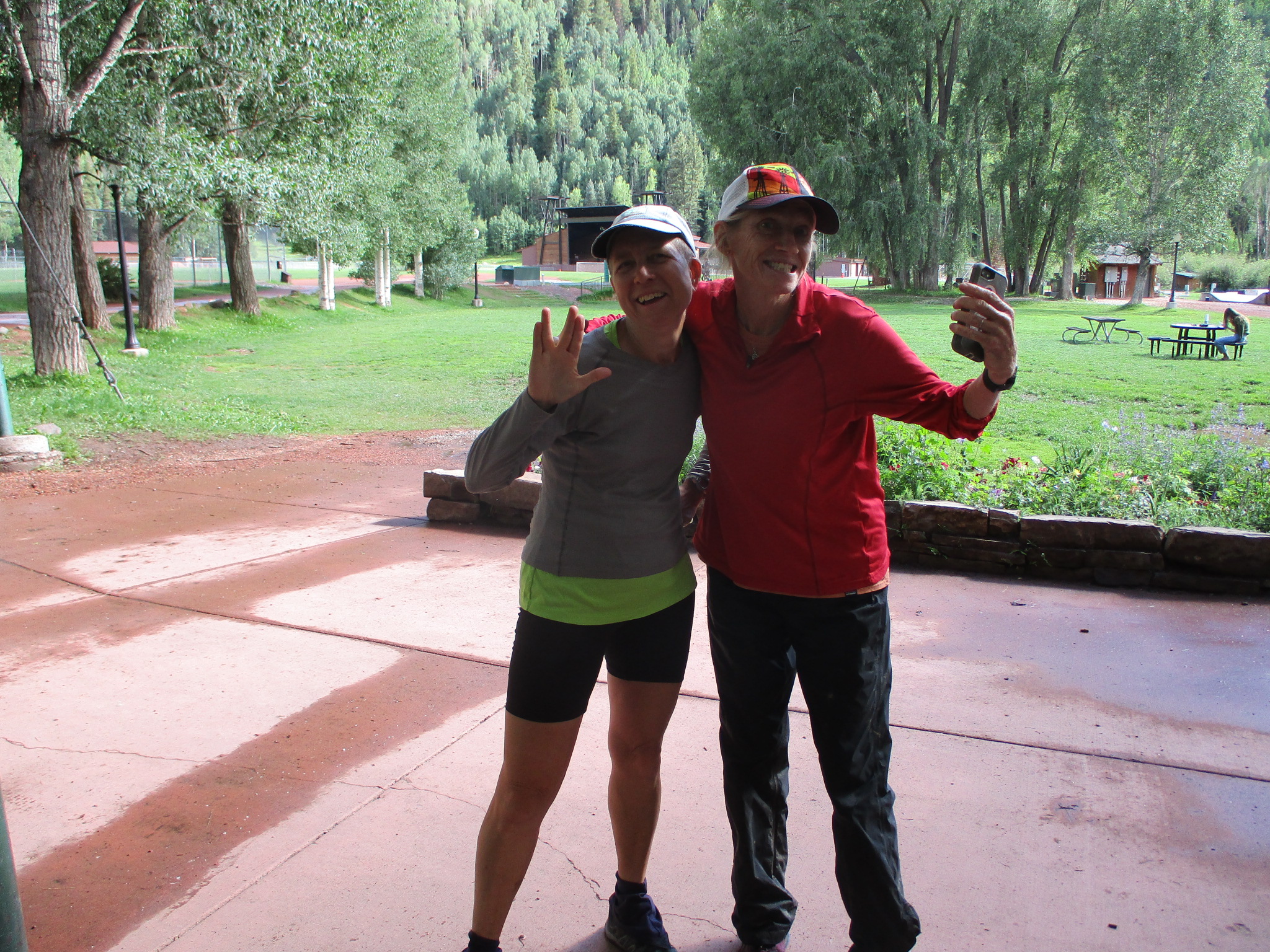
Finishing in the morning worked out great, no pressure, much less ankle pain, and a daylight photo of us kissing the rock in Silverton:

Well done, Robyn!!! You are super inspiring and a wonderful trail companion. What a fun week, excellent training, the perfect opportunity to test my UTMB pack and gear, and a great excuse to go roaming around in the Colorado mountains.
Thank you John!!! Our Super Crew was, as always, da best.