While we're in northern Arizona, we're doing a bit of exploring, nothing too crazy, just a check of the scenery every 2-3 weeks. I've had my eye on a little driving loop and we finally found the right weekend to have a go. As a bonus, there are EV chargers along the way so we are still doing 100% electric driving. No gas purchases since November, we're really enjoying that!
Plus I love driving Bev, and John doesn't seem to mind watching out the window instead.
And what a lot of stuff to see! Starting with the road down to Sedona; we've been on it before but finally stopped at the overlook on top for a look around.
We've also been in Sedona before, but never done a trail run (and only one bike ride). Why have we waited so long? It's quite spectacular.
Fun trail up to Brins Mesa:
It's easy to lose a bunch of time gawking at and taking pictures of the colors and shapes in all directions:
A century plant standing guard at the top of the mesa:
One of John's photos, I think from Soldier Pass looking south:
Thank you, Red Rock Secret Mountain Wilderness!
So much to see, and our trail map has so many more suggestions. Even the features without names (at least on this map) are awesome:
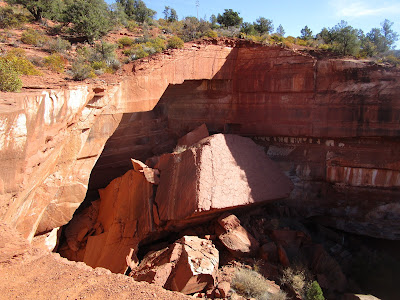
As I've stated before, anything with the word "devil" in the name is surely something we should see. This, however, is the one with the best name - Devil's Kitchen sinkhole. Someone had fun with that one.
Not only is it a GIANT sinkhole (the top of the rubble is 40-60 feet below where we were standing), an additional large chunk fell from the north end and created this sight:
People on the other side of the sinkhole, for scale (thank you, people!):
Yep, we should see Sedona more often.
We stopped at Cottonwood for free EV charging and a nice lunch along the cute little downtown block. Then paid a visit to Tuzigoot National Monument - pueblo ruins (partly recreated) are always interesting:
With a view toward the area where we did an orienteering meet last fall (we could see Tuzigoot while we were running there, that was quite neat):
Next, up the hill to Jerome, the town on the side of the hill, built with money from the local copper mine. It is a rather quirky place, with the narrow twisty streets and a bunch of tourist-type shops. Entertaining for a short visit.
Apparently it has a "famous" jail that is (was?) slowly sliding down the mountain:
It's not much in use these days:
Great view from the cell, at least!
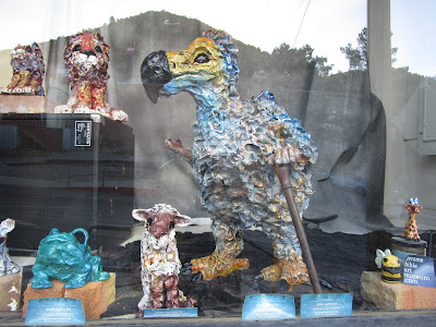
We adore the work by a local artist - she is super talented and creates animals with personality:
Less enchanted by this... well, I'm not sure what it is exactly, except hopefully the coins are collected for charitable purposes?
John's coworkers told him about the kaleidoscope store, so we waited in line to go in and browse. Worth the wait, highly recommend! They encourage everyone to pick up the cylinders, take a peek, rotate them and see what happens. Very cool, impressive, and creative.
Ahoy, Johnnie!
We finished the day by driving over the pass to Prescott, finding an excellent restaurant with an outdoor upper deck (thank you, Raven Cafe!), and walking around to check out the lights around Courthouse Plaza. I'm sure there's more to see in Prescott - next time!
Sunday morning we took an orienteering map over to an area near town and found a few "virtual checkpoints" (i.e. places where checkpoints existed for a previous O-meet). We've been enjoying playing around with these maps, getting in some practice, and seeing new areas. Thank you to Greater Phoenix Orienteering Club!
This is a popular place for mountain biking, although I'm not sure I'm ready (or will ever be ready) to ride over the top of this rock - the drop on the other side is quite something:
Fish rock, which we believe was a checkpoint - if it wasn't, it should have been:
Always enjoy running around on an interesting trail system. Especially the ones with little maps at main intersections - flashbacks to adventure racing in the northeast:
That was fun! We should do that again sometime.


