[Photo credits include Nadim Ahmed, Clinton Morse, Victoria Campbell]
The big world championship Sierra rogaine has been postponed a couple more years, but the California clubs were excited to put on an orienteering festival this summer nonetheless. And we were excited to go! It was like a practice run, with a bonus of getting to see some friends and run around in the woods.
The main downside was wildfire smoke. Earlier in the summer would be better in this area, but at least we were able to leave before it got intolerably bad a week later. Here's hoping that conditions improve for the 2023 edition.
Day 1 was down in the valley toward Sacramento, a sprint around a college campus. We're always up for a fun orienteering sprint! I started at a walk to get my head on the map, gradually picked up speed, started nailing controls one by one, and then turned the wrong way and befuddled myself for a few minutes before figuring out my mistake. This is probably a moment where I knew what I was doing:

John passed me near the end, taking the win within the Beard competition:

The college grounds with a setup worthy of a big event:

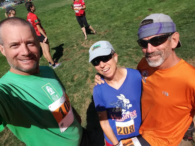
Our friend Ron from Phoenix - Hi Ron, great to see you!

One of the "professional" runners showing how it's done (and also demonstrating the AirCard technology - we might have to get us some of those eventually):

Over the weekend we were up near Donner Pass for a couple longer days. Smoke had moved in, so the starts were delayed until afternoon, and that helped with half-decent air quality.
John making tracks through the woods:

I decided to wear a mask, one that is designed for working in a dusty or smoky environment (not covid-quality because it only helps clean air intake and not outgo). It was almost comfortable and I noticed a definite difference while wearing it vs. not - both in the smell of the air (better with it on) and my ability to inhale (better with it off!). There was some wind-sucking on the uphills, so my time wasn't the best, but I was just happy to be out there so I didn't care!

Our friend Boris who has set up a new orienteering club in Montana - go Boris!

Our buddy Rex from the Bay Area, demonstrating a lunge for the finish line:

Ron, getting it done:

Slightly hazy but otherwise beautiful woods:

I wasn't the only one wearing a mask:

The long event on Sunday was extra long (at least we thought so), so we weren't around the photographers at all except right at the start. Again, happy to be there!

The starting line for the long course:

I wasn't fond of the terrain for this one, mostly because of all the logging that made for challenging footing (soft/torn up ground, a bunch of crap to pick your way over). I did enjoy the interesting navigation, and I guess extra-long just means extra time orienteering. Can't really complain about that. All good training.
Monday was a ton of fun, with a 3-person relay staged at a school near Lake Tahoe. Rex was happy to team up with us, plus he had the great idea to get a group selfie - thanks Rex!
Group start of the first runners from all the teams:

And there they go...

The first control gave a lot of people problems; there were three possible controls and Rex drew the most difficult one. He didn't give up, and he found it eventually, coming back to tag up with me:

Other racers streaming across the track:

I drew the easy first control and was quite excited to be the fast one of the team. John took off next and also had a good run:

And done!

A wide view of the school grounds where the sprint took over with tents and cones and flagging:

Super fun, thank you to BAOC for putting on all these great competitions and courses!
We were happy to be staying in a campground near Truckee, so it was easy to get to the rogaine model event at Castle Peak. A model event is a sample course where you can get familiar with the type of terrain in the area without wandering through any out-of-bounds sections of the actual rogaine. This appears to be a previous Nav-X race, looks like it was a good one!

We went out to explore and climb around on giant granite domes. That made us very happy for a few hours:

Locating "controls" consisting of flagging tape:

Found another one! We could do this all day.

John has the appropriate amount of air conditioning in one of his shoes, so he's ready for a big trek:

The following weekend was our first 24-hour rogaine in quite some time, yay! It was held at the NorthStar resort, quite a lovely place to congregate and prepare. Nav-X hosted it and did a fabulous job.
Here's the meet director, Gavin, getting ready for the map hand-out:

The giant truck parked next to our travel trailer had an appropriate decoration on top:

Team Bones doing map work:

Mark and his teammate figuring out potential routes:

We were lucky to have Howie with us, so we had indoor tables and AC. Map planning in comfort!
Gathering at the start, probably answering Gavin's question about who has never done a rogaine before or who has done some number of them:

I usually like to write a step-by-step report of our rogaines because it's fun to remember all the details. Probably less fun to read about them, though! So I'll attempt to condense the 24 hours into something shorter...
The main idea is that John decided he was ready to try to stay out the whole time, as long as it was mostly walking instead of running parts of it like we normally do. We did run a few times on Saturday afternoon but eventually we switched to walking only. My aggravated leg nerve (which usually dislikes walking, especially uphill) tuned out after a couple hours and didn't give me any real issues, so running wasn't required for me and we found a solid walking pace that worked for both of us.
In addition, the map is huge... and the start/finish is rather isolated from most of it. So we took aim at the furthest-most controls near Lake Tahoe (all the way to the lake, wow!) to see if we could get there. John suggested taking the most direct route down the east side of the map, instead of the tempting "high route" over the top of the ski area which was hard for me to resist. But it made sense, why go climb up high into the hot sun and wear ourselves out right off the bat? Let's stay mostly in the trees and try to move faster, further, and easier in the beginning.
Then we could start working up the left side of the map, spending overnight (in cooler temps) with more up-and down climbing. Hopefully the nav wouldn't be stupid challenging in the dark...
Sounds like a plan!
We took off to the east and collected a couple points near the road, climbed some smaller hills, then started dropping toward the lake. Along the way we located a couple 80 and 90 pointers, with no particular issue with the navigation. One area of logging was less fun to move through, but happily we were soon done with that and on our way toward the more-fun southern part of the map.
We really enjoyed the parks and the trails in the southern half. It made for a lovely, pleasant afternoon in the woods. A couple friends watching the leaderboard took the same screenshot of the moment when we were even in the lead of the whole thing, too funny (our team name comes from a Star Trek ship):

Most of the course was dry, so we were super excited to find a clear and cold running creek between controls #53 and 87. Using a filter bottle, we filled up our Camelbak bladders and we were set for another few hours.
I did kinda want to detour over to the school where the team relay competition had occurred the previous Monday, but since we didn't need the water we decided it was too far out of the way for only 40 points. Someone else took a picture of the stash there:

John and I were working well together on the nav, generally with me proposing the strategy for each point and John leading the way cross-country. His most masterful accomplishment was walking us directly to #65 in the middle of "it all looks the same" woods on a very shallow spur. Most impressive.
Less impressive was both of us walking right past #74, which was just off the trail, because we were both looking in the wrong direction. At least that control was much quicker to adjust for than most.
We dropped down to Tahoe City for a resupply mission, having been told to "carry money with you" and figuring it would be worth spending cash on some treats. Rather frustratingly, the map seemed to indicate that the 2 obvious convenience stores were out of bounds, so we continued along the road to the supermarket that looked legal. We stocked up on water, plus enjoyed some kombucha, yogurt, soda, and a fruit cup. Later we realized we should have picked up some chocolate bars to carry out, but we were too busy searching (pointlessly) for ice cream bars that we didn't think of that :)
Well that was fun! We had to climb up a couple extra contour lines for the detour, but it was worth it.
Back to work, trekking uphill and along a trail to find #103 with a marvelous view.
It was getting dark as we cleared the bottommost part of the course; this was about when someone online took a screenshot of our location (team #24):

Nighttime nav started out well, until we took aim at #104. We came at it from the top, which turned out to be a terrible strategy. We got down the side of the steep hill ok but then thrashed around for quite some time in thick vegetation trying to locate the proper spur. Eventually we found the spur but didn't know it until we had gone up a ways, got stuck in thick bushes, came back down to approach things differently, then ended up in the same spot. This time we found a way around the crap, but still thought we had gone too high when I just happened to catch a glimpse of something shiny up high to the right. There it is! We were lucky to locate it. Every other team came at it from the nearby trails and didn't appear to have nearly the same trouble. Nor the same amount of twigs and leaves down the backs of their shirts.
Climbing up to #75, we started seeing other teams around us (after being mostly alone most of the first 12 hours). So someone else got to witness me falling into a hole of branches and vines and yell over to John not to punch the control yet because I needed some extra time to get over there. The rules say you have to electronically punch within a short time of each other in order for it to count. Eventually I disentangled my body, almost fell in again, and finally got myself together. Well, that was exciting.
We got a couple 80-pointers without incident, then went down to cross a creek. I was hoping to find an easier way than the log John discovered, but I failed while John succeeded in threading his way through the bushes to gain the opposite bank. Sigh. He helped me manage the traverse, thank you John.
Ah, running water! We found a good fill-up spot and filtered again, very helpful.
#101 had really interesting contours around, both for finding the point and for gaining the high ground above it. We were glad to be going in this direction for that one.
Following trails, I would lead the way since I had plenty of energy and focus (my legs are so used to cruising along on trails). Off trail, John would take over and set an amazing forward pace. It was almost like he was sleepwalking when things were boring and wide awake with the excitement of bushwhacking. Whatever it was, it was working!
We almost made a mistake going to #83, climbing too much instead of contouring around the rocky hill to the south. When we finally started down into the drainage we dropped down right on top of the checkpoint. We really meant to reach the bottom well to the east of it so we'd know where we were. Ah well, sometimes it's better to be lucky than good.
One more bladder fill-up at the water drop at #31, and I believe we knew this was the last opportunity so we tanked up as much as we could.
Control #102 was quite an effort. We wanted to climb up straight at it from the northwest, but there was a large logging operation going on at the bottom of the mountain. Soft dug-up sand, dusty air, dug up roads, and a complete inability to locate the trail system drawn on the map made us thrash for a few minutes before bailing on that endeavor.
OK fine, change of plan. We trekked around on the road to #50 first and then started up the mountain from the northeast. Little roads and trails got us most of the way there, and it was light out by the time we were ready to traverse around to the saddle. Score.
Getting from the saddle around to the trail on the ridge proved surprisingly more difficult, but eventually we got there. While collecting a few more high points we realized that although it was dawn, there was no sun. And it was starting to smell like smoke. Blech. We got out our masks for the remaining hours, not wanting to expose our lungs to the smoke pollution that was rolling in.
Since we were walking and not running, that worked fine. It slowed down some of our uphill efforts, but at least we were fairly high up at the time. We were excited to have enough time to veer over to #94 before starting down the ski slopes toward #95. John saved me by correctly reading the vegetation around #95 (woods, not open ski slope), then found an excellent log to get us through the dark green below it and gain the field. Nice one.
We found a chair lift with an accessible chair, so John hoisted me up and we sat there eating a snack for a few minutes. What a lovely way to spend the morning with my husband.
Time to get going, and just enough time for #51 before we needed to be moving toward the finish line. We got a couple more small-value controls along the way and then moseyed through the resort neighborhoods until we got back to where we had started.
That was great fun! We sort of impressed ourselves as well :)
High five:

Not long after, someone created an online jigsaw puzzle using the map and some photos from the event, and we even made the cut, pretty funny:

Thank you to all the people that put on these events, that was spectacular! We're looking forward to coming back in 2023.
No comments:
Post a Comment