We used to do more adventure races, many of them in Texas, and especially Too Cool Racing's events. When we heard that Too Cool was putting on one last Big Chill race (the 20th edition) almost exactly on John's 60th birthday, it sounded like something we needed to do.
After all, we were there 10 years ago.
So we borrowed a bike rack and drove to Lake Somerville in central Texas for the weekend. Dave was happy to join us, but sadly our friend Jason got Covid the week before and had to stay home :( We missed you, Jason!
Hello from Team Vignette (one more time racing together!)

Photo credits to Jillian Cook, David Bogle, and Danny Ballard
One of the most delightful aspects of the trip was getting to see friends and fellow racers we haven't seen in quite some time. Getting prepped for the race was a balancing act between talking with everyone and making sure our gear was in order. Even better, John's parents drove down from East Texas to experience an adventure race first-hand. Thanks for being there, Jenny and Jerry!

Dave also wrote a race report - double documentation! (And more pictures plus the maps - thanks Dave!)
The race started with a quick run around a park loop, with a brief pause to pick up a poker chip (manned by our friend Danny) along the way. Tom and John got assigned chip pickup duty:

We trotted back to the TA and turned in the poker chip in exchange for our first punch card. The first leg involved biking on roads (close to our AirBnB lodging, as it turned out) and pausing to find checkpoints along creeks and near the lake shore. Despite a lack of bike training for me and especially for John, we managed to hit this one pretty hard and maintain some semblance of speed.
Race temperatures worked out great - only slightly chilly standing around before the start, then perfect weather for racing in tights and long sleeves, never too hot.
The downside to the weather was the wind, which only affected the paddle leg. But boy, did it affect it. I wasn't really keen on sitting in the middle seat of a Kevlar canoe in the middle of a windy lake. We put on rain jackets and pants to stay warm and went down to the boat ramp to get this over with...
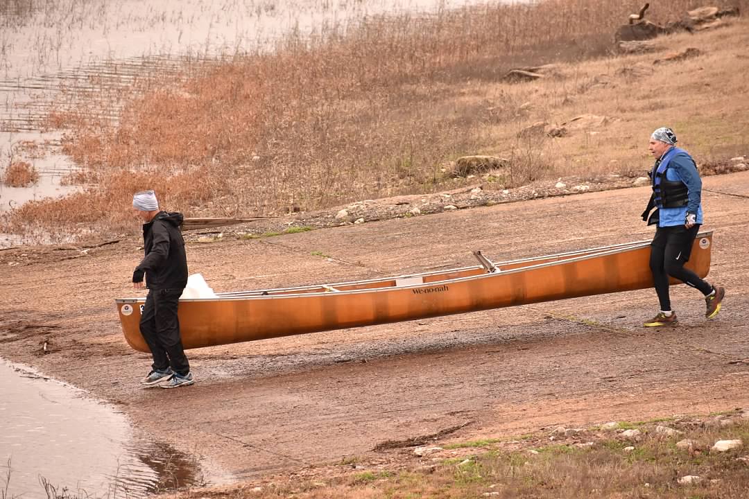
At least the launch was into some reeds for a ways so we didn't have any immediate waves:

Once we broke out of the reeds, we had to deal with a side wind. Not great. We've certainly had worse conditions so we had some idea how to stay balanced (even though it's more difficult with 3 people in the boat). We watched a couple other boats ahead of us and I tried to sort out what I was seeing vs. the map. Finally I figured out where we had come from (behind a map fold) and realized we had a fairly wide crossing ahead of us.
The closest paddle checkpoint was on the south shore, and the wind was blowing from the north, while we were paddling east. We decided to tack northeast instead and aim for the boat drop on the north shore. There were several trekking checkpoints on the north side and we really wanted to get those.
Once we made it over to the north shore, we tucked behind a jut-out and found much calmer waters. That made it easy to reach the boat drop, phew. We could see other teams getting the first paddle point and heading further east to the far points, but it didn't look like much fun.
Glad to be out of the boat for the time being, we chatted briefly with Art and then started out on foot. The checkpoints were scattered along trails and roads, with one off-trail option to cut off distance. Mostly straightforward nav. Dave has been dealing with knee issues, so we alternated walking and running.
Along the way we discussed the big upcoming trekking leg, the last two short legs (with quite a few checkpoints between them), and the 3 paddle checkpoints on the south side of the lake. Was it worth attempting to do the entire paddle or should we just return to TA? We knew we could easily fly downwind to the other shore, but then what? Sideways waves all the way back?
Since that didn't sound like fun, we took the "skip it" option and started talking about the best way to get back. The protected north shore was obviously a good place to start. Once we rounded the jut-out, we aimed northwest to get back into protected waters for as long as possible. Then we turned south and scooted directly across and downwind to the TA.
Yay, we made it!

Time to get out of all those waterproof clothes and go for a walk. We grabbed water and more snacks (hello wonderful crew!) and then started up the road.
The next nav question was how to get one of the trek checkpoints. It was along a trail, but the trail ended at a creek and apparently the bridge was out. Earlier in the week the area was hit with big rains, enough to refill a once-low lake and make all the creeks rise. Art and Robyn told the teams to not even try to cross them.
OK, then how best to reach the checkpoint? There was a small road that ended not far from it, so we figured we could try jumping in from there and bushwhacking down. When we reached a "no trespassing" sign, we paused. A truck drove up - good timing! - and we talked to one of the landowners who told us it wasn't possible to do what we were thinking (private property and all that).
Guess we'll go around and figure out that checkpoint on our way back. Sometimes our ingenious shortcuts don't work out, but it's (usually) worth a try. So we returned to the main road and hoofed it down another road toward the trail system.
Along the way the road crossed over the creek, and the creek looked really low and calm. Hmm, maybe something to keep in mind for the return trip. For now, it was time to circumnavigate the large Flag Pond.
We found the doubletrack leading to the trails and started picking off CP's. Dave was still moving great, a mix of running and walking at a solid clip. I had volunteered for "punch card duty" on this leg - although that was before I knew one of the checkpoints was water-based. Here's Robyn hanging the control before the race. Apparently this tree was on the shoreline before the recent big rains:

Another checkpoint was noted as being up in a tree so we sent John over to climb it. Sadly for John, the punch was accessible from the ground:

This seemed like a good location to sit for a couple minutes and eat something:

After an out-and-back to the far CP, we continued our Tour de Flag Pond and found a new structure (Dave has been here a couple times and hadn't seen it before). Fun location for a checkpoint:

We walked for a bit with a local fisherman and chatted about his adventures with friends. The guy got in his boat on the canal outlet from the lake, and I'm guessing Dave might have enjoyed a ride back but we continued on by foot and Dave never complained.
Well, we've got to finish up this leg with CP21 on the other side of the creek. Just in case the creek was actually crossable (somewhere other than over the road bridge) we jogged over to take a look. It would have cut off some distance if that had worked.
The creek itself didn't look bad, just lazy and brown. The problem turned out to be the steep and deep muddy banks on both sides. Getting down would have been slippery (and probably uncontrolled) and getting up the other side looked really messy and challenging. Fine, we'll go around!
Back to the road, over the bridge, and then along the side of the hill until we reached the bank on the other side of the creek from where we recently were. From there the trail was easy to follow, just twisty back-and-forth and up-and-down.
The good thing about it was that once we got the last trek checkpoint, we were soon following the course of the next bike leg. We put eyes on a couple of those checkpoints and also had a chance to see the trail while it was still daylight. There were muddy and wet sections, also some places we'd be able to ride faster. For me especially, this scouting would prove helpful.
We saw several teams out on the next bike leg, a couple who were on their way to clearing the course and others who had skipped some points. No idea where we stood in the pack but it didn't matter - we were there for fun, of course!
Once we got back to TA (not long after sunset) and back on the bike, I had less fun but I'm guessing Dave and John were a lot happier. Dave took over the nav and we started hitting CP's right and left. It works out when John and Dave can pause to punch the card while I catch up and pass them briefly, and then let them by when they ride back to me. Mostly I was just pleased that I rode the whole first section without getting off.
That changed when we rode south for the last couple bike points in a new area. That trail was horrendously muddy. If I'd known that, I would have left my bike at the trailhead and run (much faster for me at least). We reached an intersection where we expected to find a checkpoint but it wasn't there. Thinking that it might be missing, we took this picture to show we were there:

Then we heard from another team that it was actually further along. If we'd paid attention to the park trail map instead of just the topo map, we might have figured it out. Instead there was some biking back and forth, finally punching both remaining bike CP's.
And finally we were back out on the paved park road, glad to be out of the mud!
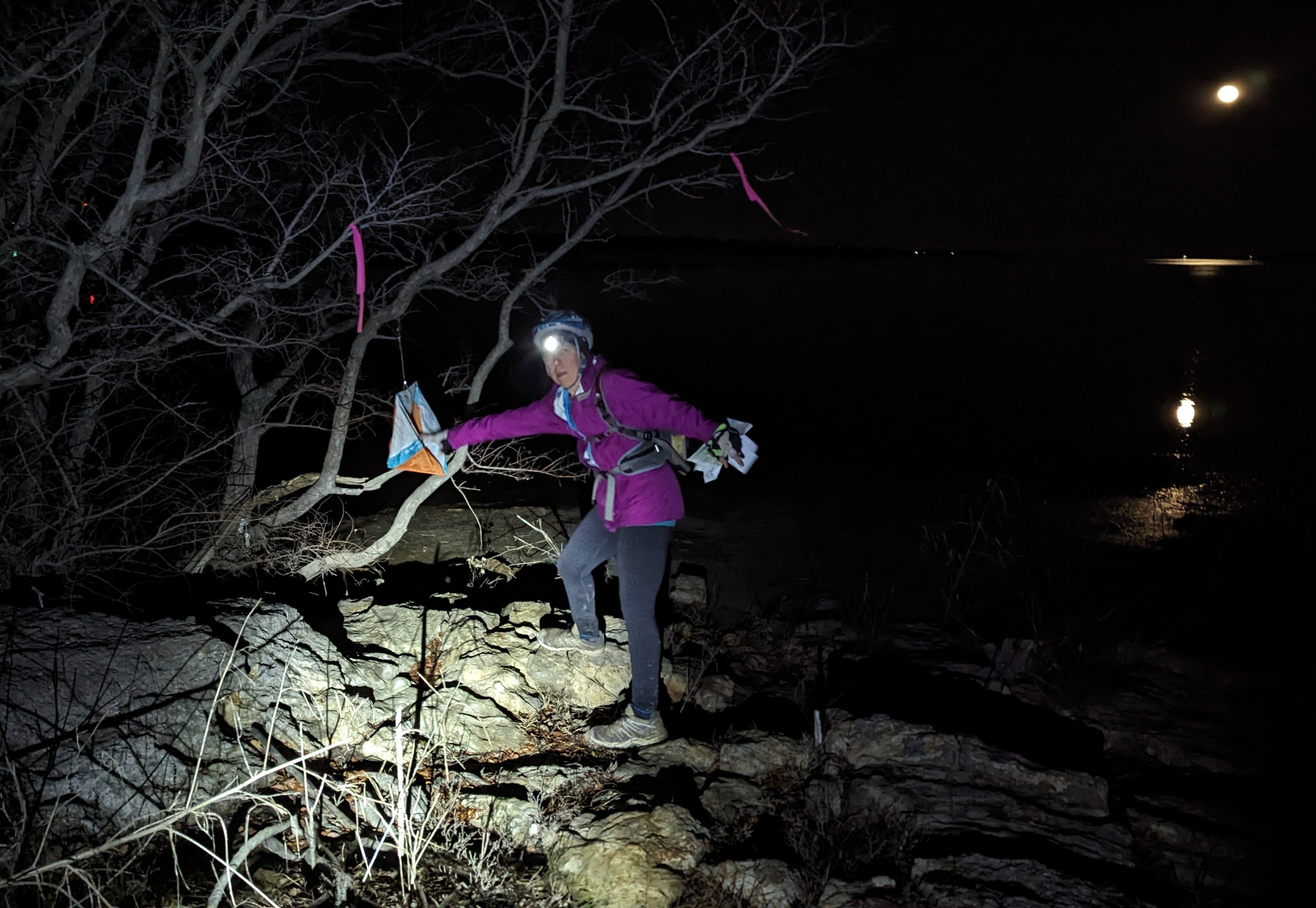
We hustled back to the TA and did a quick transition to the final trekking section. It was short but had 5 checkpoints, a leg we didn't want to miss. Dave said he wasn't used to racing the clock to finish within a time limit, while John and I have had plenty of rogaine orienteering experience recently. I was pretty confident we could collect all 5. Dave was motivated to do some running to make sure. Works for me!
We took off, me still wearing my helmet and bright headlamp and not carrying a Fenix hand light - not my normal night nav setup, to be sure. No matter, we worked well as a team and ran around the nearby trails to get those checkpoints.
A quick picture of the one on the peninsula, where the punch was missing (and the moon was rising):
We hustled to the last overlook and then back to TA. Made it with 13 minutes to spare, yay!
It turned out that skipping those 3 paddle points was the best decision we made all race. It gave us time to (barely) finish all of the remaining legs. Sometimes you get lucky - by maximizing the number of CP's we were able to collect plus minimizing our time on the windy lake.
Top co-ed team and 4th overall, pretty good for some "vintage" racers! Art and Robyn seem to agree, or maybe they just like messing with us:

Thank you Art and Robyn for all the wonderful, fun, challenging races you have put on over the years! We were so pleased to participate in the final Big Chill, it was another good one.
Some other somewhat-related pictures...
Happy birthday John! (with Louisiana King Cake to celebrate, his parents in the mirror and a fire extinguisher at the ready)

One of two roadrunner statues we saw on our drive to/from Texas:

And the other one (in New Mexico) - love it!

And finally, a picture to summarize how much we enjoyed hanging out with friends and family, thank you Danny, Jillian, and everyone else who was there!

No comments:
Post a Comment