Friday, December 22, 2023

Climbing Arizona mountains

Arizona has some excellent peaks to explore, and we spent several weeks in September/October seeing one "old friend" and some new ones too.

I got really lucky with timing on our return drive from the Collegiate Loop heading back to Tucson.  Our friend Taylor hosted us at her house (thank you Taylor!) and cheered me on when it looked like the Hole to Hump FKT might be in the cards.  "Hole to Hump, Hole to Hump!" she rallied - too funny!

Previous experiences on either end of this route helped with the planning, and of course any time we get a chance to head down into the Grand Canyon, I'm pretty sure I've mentioned before that we will always be excited about it.

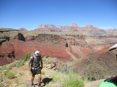
I mean, come on:


We wandered down the New Hance trail in the morning, following the bottom wash to the river:


Nature is so cool:


Once again we just happened to be at the river in time to see some rafts, in this case park service motor boats.  They zoomed right over the rapids like no big deal:


Hello from the Colorado River!


Admiring the surrounding geology and layers:


Firing up the InReach Mini to begin tracking my progress from the "hole" to the "hump":


I wrote a fairly detailed report, with a few more pictures, on the FKT website.

Briefly... the climb up New Hance trail was warmer and slower than my previous ascent, but still reasonable, and very much still pretty:


The roads across the prairie were in great shape for running and driving.  Good thing, because I needed to run as much as possible to have a chance at the fastest known time.  John crewed me every few miles and took a couple pictures while it was still light out:


Overnight was dark, cool, calm, mostly straightforward.  I kept on running, all the while wondering if I had it in me to climb Humphrey's Peak fast enough the next morning?

We started up the mountain right around dawn and John led the way straight up the ski slopes.  A couple months after the fact, I still remember how difficult this climb was for me - one foot in front of the other, keep breathing, keep stepping, don't think just follow.  You get there in time or you don't.  Adrenaline must have helped, I can only imagine.

Wind at the top was crazy!  That was the only negative part of the forecast.  Luckily it didn't delay us until the very last little "hump", where I actually crawled up the final few rocks.  Thank goodness for the protective barrier built up at the top for a bit of respite:


So excited to have made it!


Fun timing, as this just came out recently:


I'm always interested in seeing the FKT of the Year nominee list, because it's a wonderful celebration of all the incredible accomplishments in the last 12 months:


And wait - what?? - someone nominated me, first time that has happened!  Makes me smile to think about it.  Thank you to whoever recognized that effort!  I am humbled and honored to be included with many other inspiring and talented women.


Continuing south through Arizona, we stopped at the new Sedona Rivian EV charger, pleased that this is here now:


Looks like someone has been driving on dirt roads:


Back in Tucson, ready to tackle my ever-evolving list of places to roam in the mountains around the city.

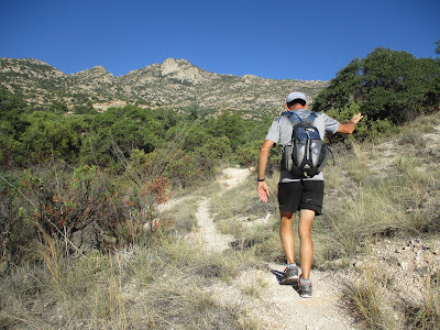
First up, a mountaintop we can see from our RV park (and many other vantage points) - Rincon Peak.  It's pointy and remote, and it took a bit of a drive just to get to the trailhead on the back side.  Happy to finally find the time to make the trek:


Up on the saddle between Mica and Rincon, with the summit on the horizon:


The final climb is steep but way more doable than I had suspected after seeing the peak from an airplane window last year.  The giant cairn on top, with broad Mica in the background and the Catalina range in the distance:


A distinctive Alligator Juniper as we started down:


Another distinctive... something:


THIS apple?


Scat, bear, scat!  (Or as I like to yell in a cheerleader voice, "go bear go!")


Let's see, what's next?  Ah yes, something shorter but even steeper - Pusch Peak.  It's the lowest high point on the western end of the Catalina ridge, with a sort-of-a-trail that feels like it goes straight uphill even though it looks like a roundabout traverse.

A headstand-y bug welcomes us:


View of town from within an early morning shadow:


Two thumbs up for adventure!


Photogenic prickly pear:


Made it to the top, with the reward of a view toward Bighorn Peak and then Table Mountain just visible over the top of Bighorn:


Which apparently got us wondering about Table Mountain.  It's such an obvious and curious feature from most of the Tucson area.  And it's climbable (at least outside the "Bighorn closure" months).  Let's try it!

View of Table from the Pima Canyon trail (and I realize now that I don't have any good photos of Table Mountain from further away, which would give some context to its shape - I'll have to work on that for a future post):


Starting up the off-trail ascent, with slab walking and rock hopping and pokey plant avoidance:


Looking down the slot toward Oro Valley, as we're about to reach the table portion of the mountain:


An excellent vantage point from the top.  I believe that's Catalina State Park down there:


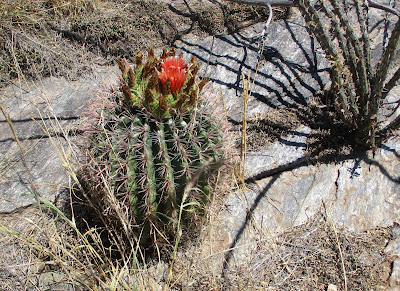
One of the spiky plants to avoid - although as much as a barrel cactus looks sharp and nasty, we've had very little issue with them.  Probably because they are obvious and sometimes come with pretty flowers.  And I've probably jinxed myself now.


On our way down to go search for some ice cream:


We're enjoying our return to southern Arizona for the winter, so much more to see!

Thursday, December 14, 2023

Collegiate Loop with Robyn (part 2 of 2)

Back on the trail with Robyn!

The weather turned chilly for our overnight near Winfield.  The previous days had been nice, warm, sometimes even hot.  After experiencing spring and summer conditions, it was time for autumn.

Day 5 was by necessity a longer day.  We had a 21-mile section with two passes and without an obvious Tug-E meet-up spot.  Technically it was possible to drive up toward Texas Creek, but none of us really wanted to deal with the roads and all the driving to get there.  Robyn and I were perfectly happy to tackle the day without a resupply, and John was perfectly happy to have a rest/errand-running day.

Well, OK, Robyn wasn't "perfectly" happy because of the chances of rain in the forecast.  We got an early pre-dawn start to get a jump on the miles and the weather.  Robyn led the way and I was excited to see a trail I hadn't been on before.

A snack break as it was getting light, and Robyn is possibly holding the rain pants she just took off?  I'm always up for sharing goofy pictures, in any case!


Robyn took a lovely photo of the sunrise under the clouds, the only sun we would see that day:


Climbing toward Lake Ann Pass, it looks like I'm having a blast and Robyn is still wondering what we were getting into.  Don't worry, Robyn, today will be fine.  And tomorrow... is another day...


I wasn't sure why I had a taken a picture of a talus pile:


Until I saw the next close-up photo!  Good morning, little pika.  So adorable, we love you so much.


Almost to the pass after a solid uphill hike.  A few snowflakes drifted down but otherwise it was an uneventful morning.  Robyn seems to be OK with it.  Or at least slightly less concerned.


View over the other side of the pass and the clouds that stayed with us for the remainder of the day.  Robyn had experienced a very-new (just officially opened or maybe just about to be opened) trail reroute during her backpacking trip earlier in the summer.  They had put up the Colorado Trail directional arrow slightly before announcing it, and Robyn happened to reach it at exactly the wrong time.  She spent a day and a night quite confused before finally getting back to the previously-official trail.  Needless to say, we had plenty to talk about that day as we repeated her steps.


The good news was that since then, a bunch of work had been done to improve the trail conditions and we got some nice running in.

Partway through the reroute, we met a couple backpackers who asked us "what is this trail?"  It turned out they had been on an off-trail adventure when they suddenly came across this obvious trail that wasn't on their map.  We were excited to get to explain it.  It was also fun to learn that they ran a gear company and they were out testing some new packs.  If I ever remember the name of the company I'll add a link.  That's what I get for taking so long to catch up on my blog posts.

Robyn was quite interested in this tree truck lying over the trail and the first attempt at a saw cut to remove it.  One trail work week and she's ready to start fixing things "out in the wild"


We found the trail heading up along Texas Creek, briefly got lost in the willows and had to reorient, and met a couple backpackers in that area.  The most interesting guy had all his gear laid out on the ground.  We totally should have asked what that was about - drying it out?  Sorting it to repack it better?  Trying to find something?  We'll never know.

The climb toward Cottonwood Pass went fine, just another day in the high country.  There was some rain off and on (hence the lack of pictures) but no hint of thunder/lightning so we were good to go.

John got a picture of Tug-E next to two other Rivians plus one Tesla at the Rivian charging station in Salida, nice!  It sounds like Colorado is going big with Rivians as "mountain adventure trucks", love to see that.


On day 6 we found winter.

Things were fine at our lower-elevation campground, just rain and a forecast of more rain.  We dressed in our best precipitation-worthy clothes and John drove us up the hill.  Where it was snowing.  Surely it will warm up and return to raining at some point.  Right?

September on the Continental Divide:


John kept the camera, as I didn't see any need to try to protect it throughout the day.  We headed off into the wonderland of white:


For a while there wasn't much snow on the ground and it was easy to follow the trail.  Just walking through a bit of powder.  The lighting was rather odd, like we spent the day in a cloud.  Which, I guess we did.

We crossed the Divide a couple times, usually able to see ahead where the trail was taking us.  It would be neat to come back someday when it's not all white/grey and see what everything really looks like.

Perhaps halfway through the trek, we came upon a woman in a tent - what?  She popped her head out to ask if we had any dry socks?  She was thinking of trying to make it to Cottonwood Pass but she had been cold and wet when she stopped to set up camp.  She was warm and dry now, had plenty of food and stove fuel, also was in contact with people at home via her InReach, but she had the urge to get up and get moving.

We apologized that we didn't have any extra socks and suggested she might wait until it stopped snowing to start hiking again.  Clearly her clothes weren't enough for this weather and perhaps it was better to hunker down?  We had already come perhaps 6-7 miles from the pass and it was still snowing and cold.  Hopefully everything worked out for her!

We continued on, amazed at how the landscape had changed since the day before.  Robyn seemed completely at home in the snow, probably from all her skiing experience.  She started giving snow depth updates.  3 inches of accumulation.  4 inches.  We might have been up to 6 inches when it mostly stopped dropping flakes on us.

Trying to follow the trail was usually fairly straightforward, generally seeing a depression in the snow surface, and occasionally feeling the need to pull out the phone and check the track.  That typically happened at the corner of a switchback, so I got better at turning around to look upward and many times that was where we needed to go.  So interesting!

Hey Robyn, we're a couple of crazy people!


The original plan was for John to park the truck at the next trailhead and then he would cover the next (shorter) section and we'd pick him up at the other end.  It became obvious that this plan needed to change.  We were now moving way slower than anticipated and we didn't want John to have to slog through this stuff as well.

I managed to send a text from my InReach Mini to John's InReach (assuming he didn't have cell coverage either).  The texting function on the Mini isn't easy, scrolling up and down for each letter.  I didn't have a preset message that covered this situation!

Somehow I ended up unintentionally in Caps Lock and added an extra letter for the message "YOU NOO GO" -- which actually was the tone I intended and it made us laugh so I didn't try to fix it before sending.

I also sent "Come to us if possible" in case the snow continued to build up on the trail and he could help break tracks on the other end.  We were certainly getting extra exercise in that day!

Now for John's side of the story...

Here's the road on his way up to Saint Elmo:


Our truck handled it easily and there weren't any downed trees in front of him until he had parked and started hiking up the 4WD road.  He found some encroachment from leaning limbs and fallen branches.  Needless to say, it took him awhile to get there, and he had already long decided not to trek the next section of trail by the time he got my text.

He started up in our direction, taking a picture of his footprints behind him:


Robyn and I eventually made it to the last big descent, finally dropped below the "lots of snow" line, and even got to hear and see a couple pikas on the lower rocky slope.  Their footprints are SO CUTE!!

Hey, there's John!  We were all back together again, yay!  Boy, did we all have stories to relay to each other as we hiked down through the woods:


As we chatted and walked down the 4WD road, we wondered about the condition of the campground near Saint Elmo.  Did it really make sense to try to camp in this stuff?  Robyn and I threw out a few ideas like moving our Monarch Mountain Lodge stay from Saturday night to tonight.

Finally John spoke up to tell us he had already called the lodge and gotten an extra night added to our reservation - we were so grateful, laughing that he had let us talk about it for a while before letting on that he had already solved the problem.  Warm showers and warm, dry beds, woo hoo!

We discussed trail options for the final day, knowing that we could no longer complete the whole loop this time.  It made no sense to try to return to the Tin Cup/Alpine Tunnel area in these conditions.  Luckily we had the option to walk out of the lodge and over to the Boss Lake trailhead.  One final 17-mile trek would at least get us back to Monarch Pass where we had started the adventure.

I had a mild concern about a tendon on the top of one of my feet, nothing serious, probably from breaking trail in the snow.  John and Robyn were both up for doing the 17 miles, so that was the plan for day 7:


The great news was that the sun was back out!  I spent the morning moving tents and gear around on our sunny balcony so it would mostly dry, then drove up to the pass to look around.

They had PLOWED the parking lot... and the view of the mountains was very different from a few days before:


John took some pictures during their hike:


Robyn had guessed that most of the snow would quickly melt out, while I was skeptical about that.  We bet a beer on it.  I was fairly certain I was getting a free beer out of the deal.

The path up through the woods... looking a little snowy!


Yep


Making tracks up the hill:


Such a pretty place and an interesting snow line:


Robyn said later that it was amazing just how much snow was up there:


They had a great time wandering through the upper part of the Monarch ski area.  Both she and John had skied there and they said it was fun seeing all the signs and places they knew under different conditions:


Hello Robyn!


Finishing up at the pass, well done y'all!


That was quite an experience, so happy to get to spend all that time together in the Colorado mountains!  Thanks for the excellent idea, Robyn!


And someday we'll have to come back to finish what we started.